Optaşi elevation
Optaşi (Olt, Comuna Optaşi-Mãgura), Romania elevation is 201 meters and Optaşi elevation in feet is 659 ft above sea level [src 1]. Optaşi is a populated place (feature code) with elevation that is 51 meters (167 ft) smaller than average city elevation in Romania.
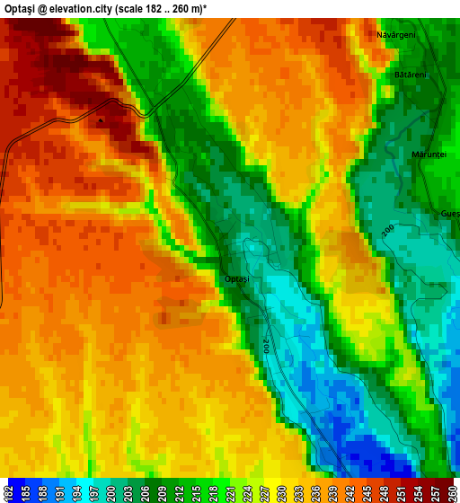
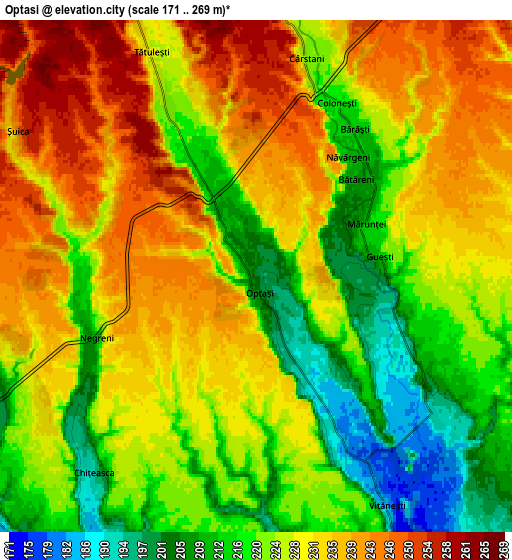
Below is the Elevation map of Optaşi, which displays elevation range with different colors. Scale of the first map is from 182 to 260 m (597 to 853 ft) with average elevation of 224.7 meters (=737 ft) [note 1]
These maps also provides idea of topography and contour of this city, they are displayed at different zoom levels. More info about maps, scale and edge coordinates you can find below images.
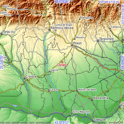
| \ | Map #1 | Map #2 | Topo.Map |
| Scale [m] | 182..260 m | 171..269 m | × |
| Scale [ft] | 597..853 ft | 561..883 ft | × |
| Average | 224.7 m = 737 ft | 226.5 m = 743 ft | × |
| Width | 6.96 km = 4.3 mi | 13.92 km = 8.6 mi | 222.7 km = 138.4 mi |
| Height | 6.96 km = 4.3 mi | 13.92 km = 8.6 mi | 222.7 km = 138.4 mi |
| ↑Max Latitude | 44.614621° | 44.645895° | 45.57628° |
| Latitude at center | 44.58333° | 44.58333° | 44.58333° |
| ↓Min Latitude | 44.552022° | 44.520698° | 43.57313° |
| ← Min Longitude | 24.606055° | 24.562109° | 23.24375° |
| Longitude center | 24.65° | 24.65° | 24.65° |
| →Max Longitude | 24.693945° | 24.737891° | 26.05625° |
Nearby cities:
Cities around Optaşi sort by population:
• Scorniceşti elevation 204 m
8.1 km,  256°
256°
• Potcoava 185 m
11.1 km,  180°
180°
• Stolnici 195 m
10.7 km,  99°
99°
• Hârseşti 182 m
11.9 km,  117°
117°
• Vitănești 181 m
7.2 km,  149°
149°
• Coloneşti 227 m
7.5 km,  10°
10°
• Negreni 209 m
4.6 km,  249°
249°
• Tătuleşti 250 m
5.7 km,  346°
346°
• Bircii 184 m
8.3 km,  206°
206°
• Potcoava Fălcoeni 207 m
10.2 km,  195°
195°
• Mărgineni Slobozia 190 m
9.4 km,  231°
231°
• Sârbii-Măgura 194 m
6.5 km,  125°
125°
Multilingual:
 En español:
Optaşi elevación 201 m.
 En France:
Optaşi élévation 201 m.


Sources and notes:
- [note 1] Map square and city borders are not equal. Map elevation data is calculated only from area inside that square.
- [src 1] Elevation data from geonames database provided with same terms of usage.
- [src 2] The elevation map of Optaşi is generated using elevation data from NASA's 3 arcsec (90m) resolution SRTM data.
- [src 3] Base (background) map © OpenStreetMap contributors tiles are generated by Geofabrik and OpenTopoMap.
Copyright & License:
This Optaşi Elevation Map is licensed under CC BY-SA. You may reuse any part from this page, if you give a proper credit by linking to this URL:
 More info on terms of use page.