Stolnici elevation
Stolnici (Arges, Comuna Stolnici), Romania elevation is 195 meters and Stolnici elevation in feet is 640 ft above sea level [src 1]. Stolnici is a seat of a second-order administrative division (feature code) with elevation that is 57 meters (187 ft) smaller than average city elevation in Romania.
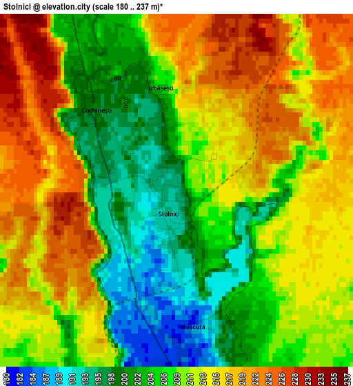
Below is the Elevation map of Stolnici, which displays elevation range with different colors. Scale of the first map is from 180 to 237 m (591 to 778 ft) with average elevation of 210.1 meters (=689 ft) [note 1]
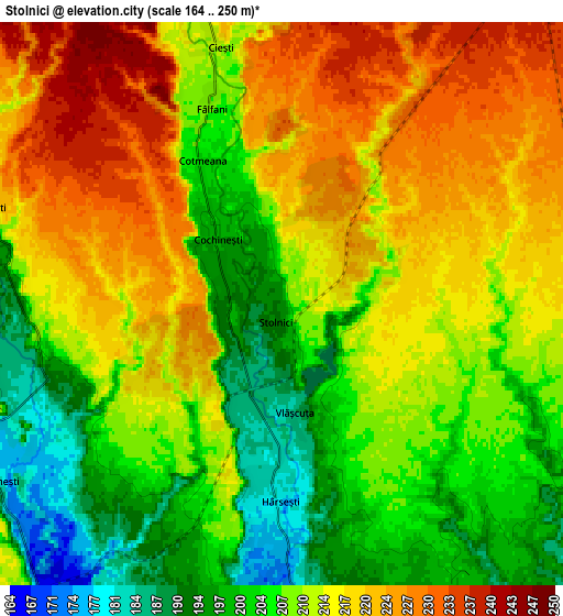
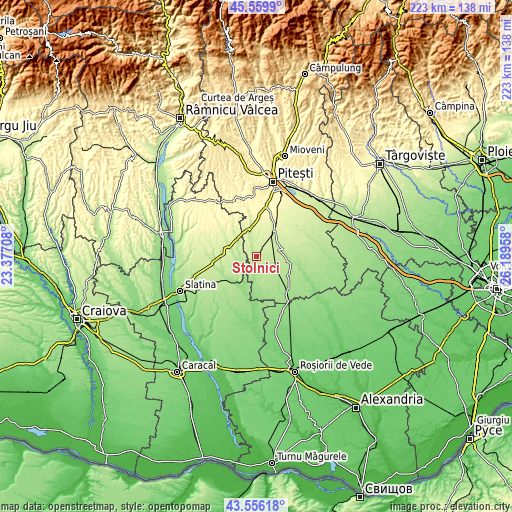
These maps also provides idea of topography and contour of this city, they are displayed at different zoom levels. More info about maps, scale and edge coordinates you can find below images.
| \ | Map #1 | Map #2 | Topo.Map |
| Scale [m] | 180..237 m | 164..250 m | × |
| Scale [ft] | 591..778 ft | 538..820 ft | × |
| Average | 210.1 m = 689 ft | 211.5 m = 694 ft | × |
| Width | 6.96 km = 4.3 mi | 13.92 km = 8.6 mi | 222.8 km = 138.4 mi |
| Height | 6.96 km = 4.3 mi | 13.92 km = 8.6 mi | 222.8 km = 138.4 mi |
| ↑Max Latitude | 44.59797° | 44.629253° | 45.5599° |
| Latitude at center | 44.56667° | 44.56667° | 44.56667° |
| ↓Min Latitude | 44.535353° | 44.50402° | 43.55618° |
| ← Min Longitude | 24.739385° | 24.695439° | 23.37708° |
| Longitude center | 24.78333° | 24.78333° | 24.78333° |
| →Max Longitude | 24.827275° | 24.871221° | 26.18958° |
Nearby cities:
Cities around Stolnici sort by population:
• Costeşti elevation 231 m
13.6 km,  35°
35°
• Buzoeşti 219 m
10.7 km,  80°
80°
• Optaşi 201 m
10.7 km,  279°
279°
• Lunca Corbului 235 m
13.2 km,  351°
351°
• Hârseşti 182 m
3.7 km,  180°
180°
• Corbu 161 m
10.7 km,  209°
209°
• Vitănești 181 m
8.2 km,  237°
237°
• Coloneşti 227 m
13.1 km,  315°
315°
• Șerboeni 234 m
11.8 km,  47°
47°
• Tătuleşti 250 m
14 km,  301°
301°
• Cornățel 211 m
13.7 km, 83°
• Sârbii-Măgura 194 m
5.6 km,  250°
250°
Multilingual:
 En español:
Stolnici elevación 195 m.
 En France:
Stolnici élévation 195 m.
 Auf Deutsch:
Stolnici höhe über dem Meeresspiegel ist 195 m.

Sources and notes:
- [note 1] Map square and city borders are not equal. Map elevation data is calculated only from area inside that square.
- [src 1] Elevation data from geonames database provided with same terms of usage.
- [src 2] The elevation map of Stolnici is generated using elevation data from NASA's 3 arcsec (90m) resolution SRTM data.
- [src 3] Base (background) map © OpenStreetMap contributors tiles are generated by Geofabrik and OpenTopoMap.
Copyright & License:
This Stolnici Elevation Map is licensed under CC BY-SA. You may reuse any part from this page, if you give a proper credit by linking to this URL:
 More info on terms of use page.