Palanca elevation
Palanca (Prahova, Comuna Râfov), Romania elevation is 87 meters and Palanca elevation in feet is 285 ft above sea level [src 1]. Palanca is a populated place (feature code) with elevation that is 165 meters (541 ft) smaller than average city elevation in Romania.
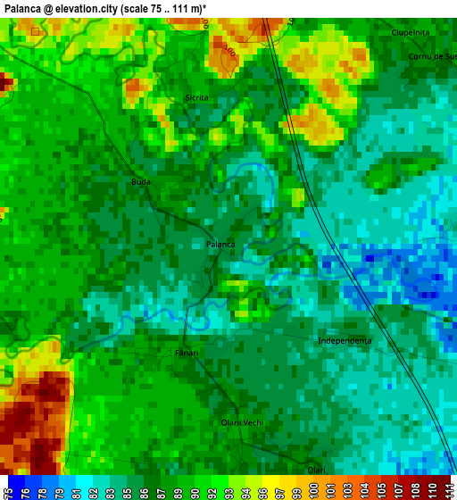
Below is the Elevation map of Palanca, which displays elevation range with different colors. Scale of the first map is from 75 to 111 m (246 to 364 ft) with average elevation of 87.8 meters (=288 ft) [note 1]
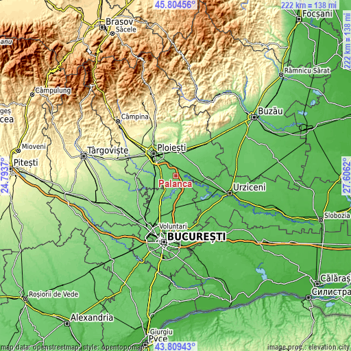
These maps also provides idea of topography and contour of this city, they are displayed at different zoom levels. More info about maps, scale and edge coordinates you can find below images.
| \ | Map #1 | Topo.Map |
| Scale [m] | 75..111 m | × |
| Scale [ft] | 246..364 ft | × |
| Average | 87.8 m = 288 ft | × |
| Width | 6.93 km = 4.3 mi | 221.8 km = 137.8 mi |
| Height | 6.93 km = 4.3 mi | 221.8 km = 137.8 mi |
| ↑Max Latitude | 44.846785° | 45.80456° |
| Latitude at center | 44.81562° | 44.81562° |
| ↓Min Latitude | 44.784438° | 43.80943° |
| ← Min Longitude | 26.156005° | 24.7937° |
| Longitude center | 26.19995° | 26.19995° |
| →Max Longitude | 26.243895° | 27.6062° |
Nearby cities:
Cities around Palanca sort by population:
• Râfov elevation 102 m
7.7 km,  317°
317°
• Drăgăneşti 73 m
7.9 km,  89°
89°
• Dumbrava 101 m
7.6 km,  350°
350°
• Gherghiţa 79 m
5.5 km,  108°
108°
• Balta Doamnei 95 m
7.8 km,  199°
199°
• Pietroșani 101 m
8 km,  289°
289°
• Siliștea Snagovului 92 m
8.7 km,  190°
190°
• Potigrafu 107 m
8.6 km,  246°
246°
• Puchenii Moșneni 103 m
8.9 km,  267°
267°
• Buda 88 m
1.5 km,  310°
310°
• Meri 77 m
8.8 km,  76°
76°
• Olari 85 m
3.7 km,  158°
158°
Multilingual:
 En español:
Palanca elevación 87 m.
 En France:
Palanca élévation 87 m.


Sources and notes:
- [note 1] Map square and city borders are not equal. Map elevation data is calculated only from area inside that square.
- [src 1] Elevation data from geonames database provided with same terms of usage.
- [src 2] The elevation map of Palanca is generated using elevation data from NASA's 3 arcsec (90m) resolution SRTM data.
- [src 3] Base (background) map © OpenStreetMap contributors tiles are generated by Geofabrik and OpenTopoMap.
Copyright & License:
This Palanca Elevation Map is licensed under CC BY-SA. You may reuse any part from this page, if you give a proper credit by linking to this URL:
 More info on terms of use page.