Olari elevation
Olari (Prahova, Comuna Olari), Romania elevation is 85 meters and Olari elevation in feet is 279 ft above sea level [src 1]. Olari is a seat of a second-order administrative division (feature code) with elevation that is 167 meters (548 ft) smaller than average city elevation in Romania.
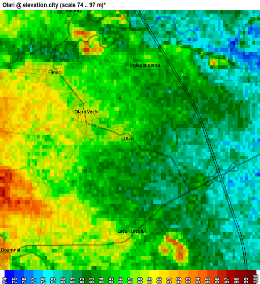
Below is the Elevation map of Olari, which displays elevation range with different colors. Scale of the first map is from 74 to 97 m (243 to 318 ft) with average elevation of 84.1 meters (=276 ft) [note 1]
These maps also provides idea of topography and contour of this city, they are displayed at different zoom levels. More info about maps, scale and edge coordinates you can find below images.
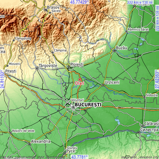
| \ | Map #1 | Topo.Map |
| Scale [m] | 74..97 m | × |
| Scale [ft] | 243..318 ft | × |
| Average | 84.1 m = 276 ft | × |
| Width | 6.94 km = 4.3 mi | 222 km = 137.9 mi |
| Height | 6.94 km = 4.3 mi | 221.9 km = 137.9 mi |
| ↑Max Latitude | 44.816002° | 45.77429° |
| Latitude at center | 44.78482° | 44.78482° |
| ↓Min Latitude | 44.753621° | 43.7781° |
| ← Min Longitude | 26.173335° | 24.81103° |
| Longitude center | 26.21728° | 26.21728° |
| →Max Longitude | 26.261225° | 27.62353° |
Nearby cities:
Cities around Olari sort by population:
• Gruiu elevation 82 m
5.9 km,  167°
167°
• Snagov 102 m
9.8 km,  195°
195°
• Drăgăneşti 73 m
7.4 km,  61°
61°
• Gherghiţa 79 m
4.2 km,  66°
66°
• Balta Doamnei 95 m
5.6 km,  225°
225°
• Siliștea Snagovului 92 m
5.9 km,  210°
210°
• Lipia 86 m
9.1 km,  155°
155°
• Potigrafu 107 m
9.2 km,  270°
270°
• Palanca 87 m
3.7 km,  338°
338°
• Merii Petchii 81 m
8.6 km,  129°
129°
• Buda 88 m
5.1 km,  330°
330°
• Meri 77 m
9 km,  52°
52°
Multilingual:
 En español:
Olari elevación 85 m.
 En France:
Olari élévation 85 m.


Sources and notes:
- [note 1] Map square and city borders are not equal. Map elevation data is calculated only from area inside that square.
- [src 1] Elevation data from geonames database provided with same terms of usage.
- [src 2] The elevation map of Olari is generated using elevation data from NASA's 3 arcsec (90m) resolution SRTM data.
- [src 3] Base (background) map © OpenStreetMap contributors tiles are generated by Geofabrik and OpenTopoMap.
Copyright & License:
This Olari Elevation Map is licensed under CC BY-SA. You may reuse any part from this page, if you give a proper credit by linking to this URL:
 More info on terms of use page.