Râfov elevation
Râfov (Prahova, Comuna Râfov), Romania elevation is 102 meters and Râfov elevation in feet is 335 ft above sea level [src 1]. Râfov is a seat of a second-order administrative division (feature code) with elevation that is 150 meters (492 ft) smaller than average city elevation in Romania.
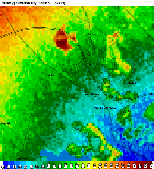
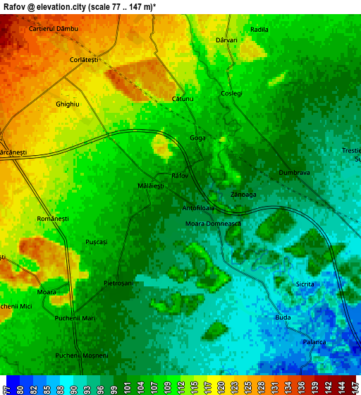
Below is the Elevation map of Râfov, which displays elevation range with different colors. Scale of the first map is from 89 to 124 m (292 to 407 ft) with average elevation of 102.7 meters (=337 ft) [note 1]
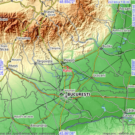
These maps also provides idea of topography and contour of this city, they are displayed at different zoom levels. More info about maps, scale and edge coordinates you can find below images.
| \ | Map #1 | Map #2 | Topo.Map |
| Scale [m] | 89..124 m | 77..147 m | × |
| Scale [ft] | 292..407 ft | 253..482 ft | × |
| Average | 102.7 m = 337 ft | 105.6 m = 346 ft | × |
| Width | 6.93 km = 4.3 mi | 13.85 km = 8.6 mi | 221.6 km = 137.7 mi |
| Height | 6.93 km = 4.3 mi | 13.85 km = 8.6 mi | 221.6 km = 137.7 mi |
| ↑Max Latitude | 44.897808° | 44.928929° | 45.85472° |
| Latitude at center | 44.86667° | 44.86667° | 44.86667° |
| ↓Min Latitude | 44.835515° | 44.804344° | 43.86136° |
| ← Min Longitude | 26.089385° | 26.045439° | 24.72708° |
| Longitude center | 26.13333° | 26.13333° | 26.13333° |
| →Max Longitude | 26.177275° | 26.221221° | 27.53958° |
Nearby cities:
Cities around Râfov sort by population:
• Bărcăneşti elevation 129 m
6.8 km,  285°
285°
• Puchenii Mari 103 m
6.8 km,  215°
215°
• Berceni 129 m
7.5 km,  349°
349°
• Dumbrava 101 m
4.4 km,  64°
64°
• Pietroșani 101 m
3.8 km, 217°
• Românești 116 m
5.3 km,  270°
270°
• Bătești 120 m
7.6 km,  254°
254°
• Puchenii Moșneni 103 m
7.1 km,  211°
211°
• Corlătești 124 m
6.3 km,  325°
325°
• Pantazi 126 m
7.6 km,  4°
4°
• Palanca 87 m
7.7 km,  137°
137°
• Buda 88 m
6.2 km, 138°
Multilingual:
 En español:
Râfov elevación 102 m.
 En France:
Râfov élévation 102 m.


Sources and notes:
- [note 1] Map square and city borders are not equal. Map elevation data is calculated only from area inside that square.
- [src 1] Elevation data from geonames database provided with same terms of usage.
- [src 2] The elevation map of Râfov is generated using elevation data from NASA's 3 arcsec (90m) resolution SRTM data.
- [src 3] Base (background) map © OpenStreetMap contributors tiles are generated by Geofabrik and OpenTopoMap.
Copyright & License:
This Râfov Elevation Map is licensed under CC BY-SA. You may reuse any part from this page, if you give a proper credit by linking to this URL:
 More info on terms of use page.