Picior de Munte elevation
Picior de Munte (Dâmboviţa, Comuna Dragodana), Romania elevation is 235 meters and Picior de Munte elevation in feet is 771 ft above sea level [src 1]. Picior de Munte is a populated place (feature code) with elevation that is 17 meters (56 ft) smaller than average city elevation in Romania.
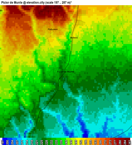
Below is the Elevation map of Picior de Munte, which displays elevation range with different colors. Scale of the first map is from 197 to 287 m (646 to 942 ft) with average elevation of 237.3 meters (=779 ft) [note 1]
These maps also provides idea of topography and contour of this city, they are displayed at different zoom levels. More info about maps, scale and edge coordinates you can find below images.
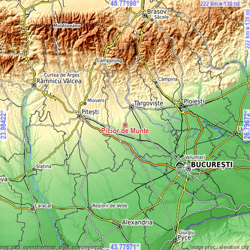
| \ | Map #1 | Topo.Map |
| Scale [m] | 197..287 m | × |
| Scale [ft] | 646..942 ft | × |
| Average | 237.3 m = 779 ft | × |
| Width | 6.94 km = 4.3 mi | 222 km = 137.9 mi |
| Height | 6.94 km = 4.3 mi | 222 km = 137.9 mi |
| ↑Max Latitude | 44.813653° | 45.77198° |
| Latitude at center | 44.78247° | 44.78247° |
| ↓Min Latitude | 44.75127° | 43.77571° |
| ← Min Longitude | 25.346525° | 23.98422° |
| Longitude center | 25.39047° | 25.39047° |
| →Max Longitude | 25.434415° | 26.79672° |
Nearby cities:
Cities around Picior de Munte sort by population:
• Găeşti elevation 186 m
9.4 km,  218°
218°
• Văcăreşti 236 m
10.5 km,  44°
44°
• Dragodana 184 m
6.3 km,  210°
210°
• Lucieni 253 m
8.2 km,  24°
24°
• Mătăsaru 173 m
7.6 km,  164°
164°
• Gura Şuţii 192 m
10.6 km,  109°
109°
• Perșinari 231 m
8.8 km,  75°
75°
• Gura Foii 199 m
9.2 km,  246°
246°
• Speriețeni 216 m
5.2 km, 110°
• Raciu 253 m
5.6 km,  45°
45°
• Odaia Turcului 173 m
10.6 km,  153°
153°
• Ungureni 271 m
9.9 km,  0°
0°
Multilingual:
 En español:
Picior de Munte elevación 235 m.
 En France:
Picior de Munte élévation 235 m.
 Auf Deutsch:
Picior de Munte höhe über dem Meeresspiegel ist 235 m.

Sources and notes:
- [note 1] Map square and city borders are not equal. Map elevation data is calculated only from area inside that square.
- [src 1] Elevation data from geonames database provided with same terms of usage.
- [src 2] The elevation map of Picior de Munte is generated using elevation data from NASA's 3 arcsec (90m) resolution SRTM data.
- [src 3] Base (background) map © OpenStreetMap contributors tiles are generated by Geofabrik and OpenTopoMap.
Copyright & License:
This Picior de Munte Elevation Map is licensed under CC BY-SA. You may reuse any part from this page, if you give a proper credit by linking to this URL:
 More info on terms of use page.