Mătăsaru elevation
Mătăsaru (Dâmboviţa, Comuna Mătăsaru), Romania elevation is 173 meters and Mătăsaru elevation in feet is 568 ft above sea level [src 1]. Mătăsaru is a seat of a second-order administrative division (feature code) with elevation that is 79 meters (259 ft) smaller than average city elevation in Romania.
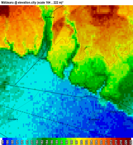
Below is the Elevation map of Mătăsaru, which displays elevation range with different colors. Scale of the first map is from 164 to 222 m (538 to 728 ft) with average elevation of 186.7 meters (=613 ft) [note 1]
These maps also provides idea of topography and contour of this city, they are displayed at different zoom levels. More info about maps, scale and edge coordinates you can find below images.
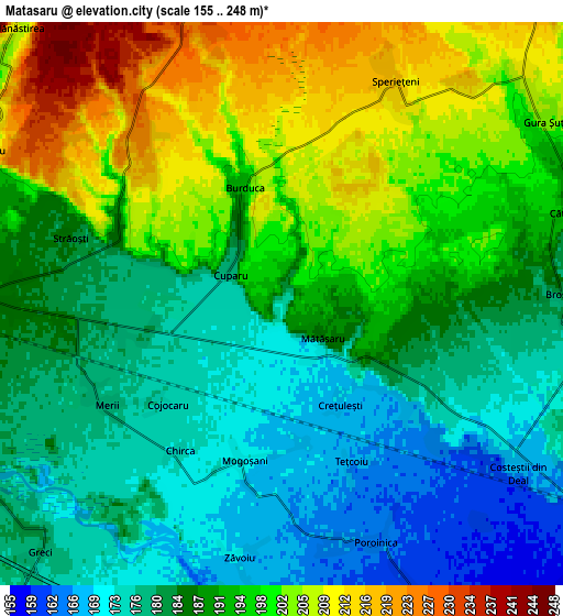
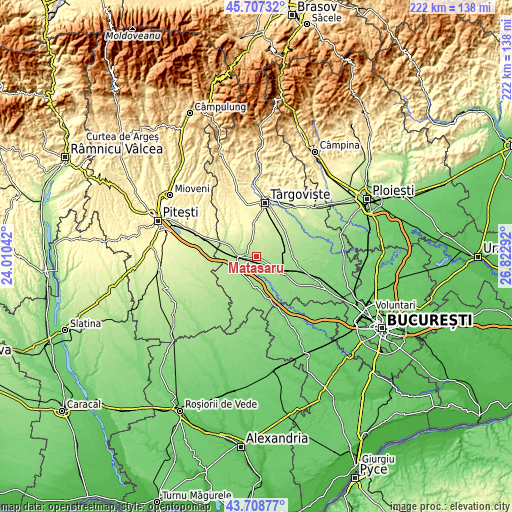
| \ | Map #1 | Map #2 | Topo.Map |
| Scale [m] | 164..222 m | 155..248 m | × |
| Scale [ft] | 538..728 ft | 509..814 ft | × |
| Average | 186.7 m = 613 ft | 189.4 m = 621 ft | × |
| Width | 6.94 km = 4.3 mi | 13.89 km = 8.6 mi | 222.2 km = 138.1 mi |
| Height | 6.94 km = 4.3 mi | 13.89 km = 8.6 mi | 222.2 km = 138.1 mi |
| ↑Max Latitude | 44.747889° | 44.779091° | 45.70732° |
| Latitude at center | 44.71667° | 44.71667° | 44.71667° |
| ↓Min Latitude | 44.685434° | 44.654182° | 43.70877° |
| ← Min Longitude | 25.372725° | 25.328779° | 24.01042° |
| Longitude center | 25.41667° | 25.41667° | 25.41667° |
| →Max Longitude | 25.460615° | 25.504561° | 26.82292° |
Nearby cities:
Cities around Mătăsaru sort by population:
• Găeşti elevation 186 m
7.9 km,  270°
270°
• Dragodana 184 m
5.6 km,  289°
289°
• Mogoşani 171 m
3.9 km,  199°
199°
• Produleşti 172 m
6.8 km,  105°
105°
• Picior de Munte 235 m
7.6 km,  344°
344°
• Speriețeni 216 m
6.2 km,  27°
27°
• Odaia Turcului 173 m
3.4 km,  127°
127°
• Broșteni 180 m
7.3 km,  86°
86°
• Greci 178 m
8.4 km,  223°
223°
• Zăvoiu 170 m
6.3 km,  189°
189°
• Costeștii din Deal 169 m
7 km,  124°
124°
• Tețcoiu 167 m
4.2 km,  156°
156°
Multilingual:
 En español:
Mătăsaru elevación 173 m.
 En France:
Mătăsaru élévation 173 m.
 Auf Deutsch:
Mătăsaru höhe über dem Meeresspiegel ist 173 m.

Sources and notes:
- [note 1] Map square and city borders are not equal. Map elevation data is calculated only from area inside that square.
- [src 1] Elevation data from geonames database provided with same terms of usage.
- [src 2] The elevation map of Mătăsaru is generated using elevation data from NASA's 3 arcsec (90m) resolution SRTM data.
- [src 3] Base (background) map © OpenStreetMap contributors tiles are generated by Geofabrik and OpenTopoMap.
Copyright & License:
This Mătăsaru Elevation Map is licensed under CC BY-SA. You may reuse any part from this page, if you give a proper credit by linking to this URL:
 More info on terms of use page.