Ungureni elevation
Ungureni (Dâmboviţa, Comuna Dragomireşti), Romania elevation is 271 meters and Ungureni elevation in feet is 889 ft above sea level [src 1]. Ungureni is a populated place (feature code) with elevation that is 19 meters (62 ft) bigger than average city elevation in Romania.
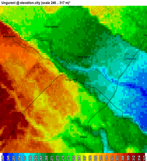
Below is the Elevation map of Ungureni, which displays elevation range with different colors. Scale of the first map is from 246 to 317 m (807 to 1040 ft) with average elevation of 281.1 meters (=922 ft) [note 1]
These maps also provides idea of topography and contour of this city, they are displayed at different zoom levels. More info about maps, scale and edge coordinates you can find below images.
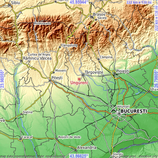
| \ | Map #1 | Topo.Map |
| Scale [m] | 246..317 m | × |
| Scale [ft] | 807..1040 ft | × |
| Average | 281.1 m = 922 ft | × |
| Width | 6.93 km = 4.3 mi | 221.6 km = 137.7 mi |
| Height | 6.93 km = 4.3 mi | 221.6 km = 137.7 mi |
| ↑Max Latitude | 44.902605° | 45.85944° |
| Latitude at center | 44.87147° | 44.87147° |
| ↓Min Latitude | 44.840318° | 43.86625° |
| ← Min Longitude | 25.347855° | 23.98555° |
| Longitude center | 25.3918° | 25.3918° |
| →Max Longitude | 25.435745° | 26.79805° |
Nearby cities:
Cities around Ungureni sort by population:
• Târgovişte elevation 283 m
7.9 km,  40°
40°
• Dragomireşti 295 m
6.8 km,  317°
317°
• Văcăreşti 236 m
7.6 km,  108°
108°
• Lucieni 253 m
4.1 km,  126°
126°
• Ulmi 254 m
9.1 km,  69°
69°
• Valea Voievozilor 272 m
10.4 km, 44°
• Picior de Munte 235 m
9.9 km,  180°
180°
• Teiș 327 m
10.2 km,  4°
4°
• Decindeni 311 m
6.9 km,  311°
311°
• Râncăciov 305 m
3.3 km, 305°
• Raciu 253 m
7.1 km,  146°
146°
• Viișoara 261 m
3 km, 68°
Multilingual:
 En español:
Ungureni elevación 271 m.
 En France:
Ungureni élévation 271 m.
 Auf Deutsch:
Ungureni höhe über dem Meeresspiegel ist 271 m.

Sources and notes:
- [note 1] Map square and city borders are not equal. Map elevation data is calculated only from area inside that square.
- [src 1] Elevation data from geonames database provided with same terms of usage.
- [src 2] The elevation map of Ungureni is generated using elevation data from NASA's 3 arcsec (90m) resolution SRTM data.
- [src 3] Base (background) map © OpenStreetMap contributors tiles are generated by Geofabrik and OpenTopoMap.
Copyright & License:
This Ungureni Elevation Map is licensed under CC BY-SA. You may reuse any part from this page, if you give a proper credit by linking to this URL:
 More info on terms of use page.