Sărata elevation
Sărata (Bacău, Comuna Sărata), Romania elevation is 242 meters and Sărata elevation in feet is 794 ft above sea level [src 1]. Sărata is a seat of a second-order administrative division (feature code) with elevation that is 10 meters (33 ft) smaller than average city elevation in Romania.
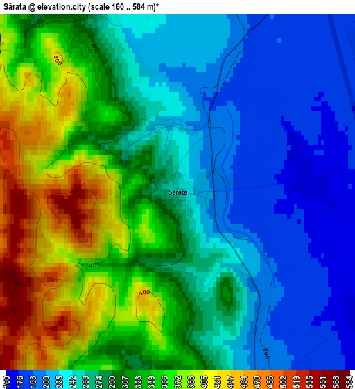
Below is the Elevation map of Sărata, which displays elevation range with different colors. Scale of the first map is from 160 to 584 m (525 to 1916 ft) with average elevation of 292 meters (=958 ft) [note 1]
These maps also provides idea of topography and contour of this city, they are displayed at different zoom levels. More info about maps, scale and edge coordinates you can find below images.
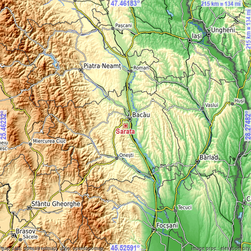
| \ | Map #1 | Topo.Map |
| Scale [m] | 160..584 m | × |
| Scale [ft] | 525..1916 ft | × |
| Average | 292 m = 958 ft | × |
| Width | 6.73 km = 4.2 mi | 215.3 km = 133.8 mi |
| Height | 6.73 km = 4.2 mi | 215.2 km = 133.7 mi |
| ↑Max Latitude | 46.53273° | 47.46183° |
| Latitude at center | 46.50249° | 46.50249° |
| ↓Min Latitude | 46.472233° | 45.52591° |
| ← Min Longitude | 26.824625° | 25.46232° |
| Longitude center | 26.86857° | 26.86857° |
| →Max Longitude | 26.912515° | 28.27482° |
Nearby cities:
Cities around Sărata sort by population:
• Bacău elevation 165 m
8 km,  25°
25°
• Nicolae Bălcescu 162 m
5.4 km,  137°
137°
• Faraoaní 206 m
8.1 km,  162°
162°
• Letea Veche 153 m
8.2 km,  49°
49°
• Luizi-Călugăra 322 m
4.4 km,  321°
321°
• Măgura 248 m
7.3 km,  348°
348°
• Ungureni 141 m
6.4 km,  75°
75°
• Dămoc 261 m
4 km,  182°
182°
• Valea Seacă 229 m
4.3 km,  167°
167°
• Osebiți 314 m
4.6 km,  330°
330°
• Barați 181 m
8.1 km,  1°
1°
• Galbeni 136 m
7.9 km,  130°
130°
Multilingual:
 En español:
Sărata elevación 242 m.
 En France:
Sărata élévation 242 m.


Sources and notes:
- [note 1] Map square and city borders are not equal. Map elevation data is calculated only from area inside that square.
- [src 1] Elevation data from geonames database provided with same terms of usage.
- [src 2] The elevation map of Sărata is generated using elevation data from NASA's 3 arcsec (90m) resolution SRTM data.
- [src 3] Base (background) map © OpenStreetMap contributors tiles are generated by Geofabrik and OpenTopoMap.
Copyright & License:
This Sărata Elevation Map is licensed under CC BY-SA. You may reuse any part from this page, if you give a proper credit by linking to this URL:
 More info on terms of use page.