Ungureni elevation
Ungureni (Bacău, Comuna Letea Veche), Romania elevation is 141 meters and Ungureni elevation in feet is 463 ft above sea level [src 1]. Ungureni is a section of populated place (feature code) with elevation that is 111 meters (364 ft) smaller than average city elevation in Romania.
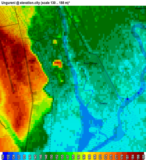
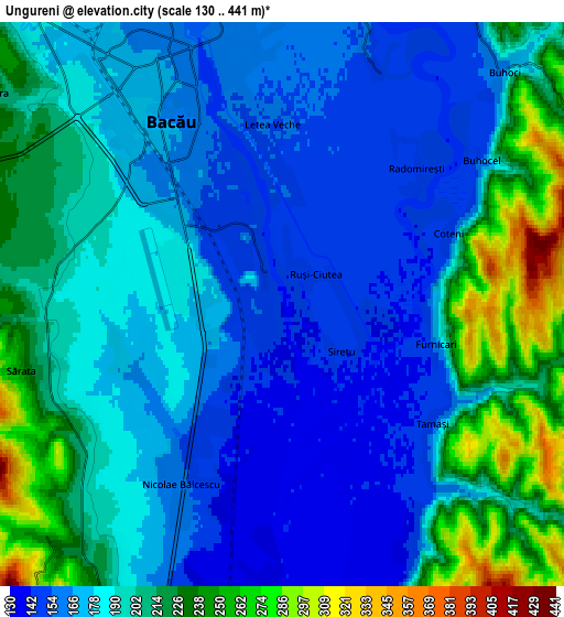
Below is the Elevation map of Ungureni, which displays elevation range with different colors. Scale of the first map is from 130 to 188 m (427 to 617 ft) with average elevation of 151.7 meters (=498 ft) [note 1]
These maps also provides idea of topography and contour of this city, they are displayed at different zoom levels. More info about maps, scale and edge coordinates you can find below images.
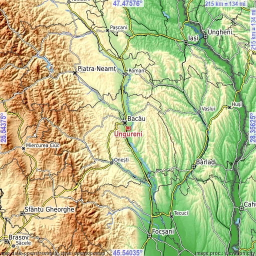
| \ | Map #1 | Map #2 | Topo.Map |
| Scale [m] | 130..188 m | 130..441 m | × |
| Scale [ft] | 427..617 ft | 427..1447 ft | × |
| Average | 151.7 m = 498 ft | 189.9 m = 623 ft | × |
| Width | 6.72 km = 4.2 mi | 13.45 km = 8.4 mi | 215.2 km = 133.7 mi |
| Height | 6.72 km = 4.2 mi | 13.45 km = 8.4 mi | 215.2 km = 133.7 mi |
| ↑Max Latitude | 46.546902° | 46.577118° | 47.47576° |
| Latitude at center | 46.51667° | 46.51667° | 46.51667° |
| ↓Min Latitude | 46.486421° | 46.456155° | 45.54035° |
| ← Min Longitude | 26.906055° | 26.862109° | 25.54375° |
| Longitude center | 26.95° | 26.95° | 26.95° |
| →Max Longitude | 26.993945° | 27.037891° | 28.35625° |
Nearby cities:
Cities around Ungureni sort by population:
• Bacău elevation 165 m
6.3 km,  333°
333°
• Nicolae Bălcescu 162 m
6.1 km,  204°
204°
• Tamaşi 141 m
4.5 km,  145°
145°
• Letea Veche 153 m
3.7 km,  0°
0°
• Buhoci 160 m
7.5 km,  42°
42°
• Dămoc 261 m
8.5 km,  228°
228°
• Valea Seacă 229 m
7.8 km,  222°
222°
• Osebiți 314 m
8.8 km,  285°
285°
• Sărata 242 m
6.4 km,  255°
255°
• Barați 181 m
8.9 km,  317°
317°
• Galbeni 136 m
6.7 km,  182°
182°
• Holt 155 m
7.1 km,  15°
15°
Multilingual:
 En español:
Ungureni elevación 141 m.
 En France:
Ungureni élévation 141 m.
 Auf Deutsch:
Ungureni höhe über dem Meeresspiegel ist 141 m.

Sources and notes:
- [note 1] Map square and city borders are not equal. Map elevation data is calculated only from area inside that square.
- [src 1] Elevation data from geonames database provided with same terms of usage.
- [src 2] The elevation map of Ungureni is generated using elevation data from NASA's 3 arcsec (90m) resolution SRTM data.
- [src 3] Base (background) map © OpenStreetMap contributors tiles are generated by Geofabrik and OpenTopoMap.
Copyright & License:
This Ungureni Elevation Map is licensed under CC BY-SA. You may reuse any part from this page, if you give a proper credit by linking to this URL:
 More info on terms of use page.