Șaroș pe Târnave elevation
Șaroș pe Târnave (Sibiu, Oraş Dumbrãveni), Romania elevation is 407 meters and Șaroș pe Târnave elevation in feet is 1335 ft above sea level [src 1]. Șaroș pe Târnave is a populated place (feature code) with elevation that is 155 meters (509 ft) bigger than average city elevation in Romania.
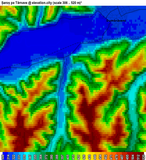
Below is the Elevation map of Șaroș pe Târnave, which displays elevation range with different colors. Scale of the first map is from 306 to 520 m (1004 to 1706 ft) with average elevation of 388.3 meters (=1274 ft) [note 1]
These maps also provides idea of topography and contour of this city, they are displayed at different zoom levels. More info about maps, scale and edge coordinates you can find below images.
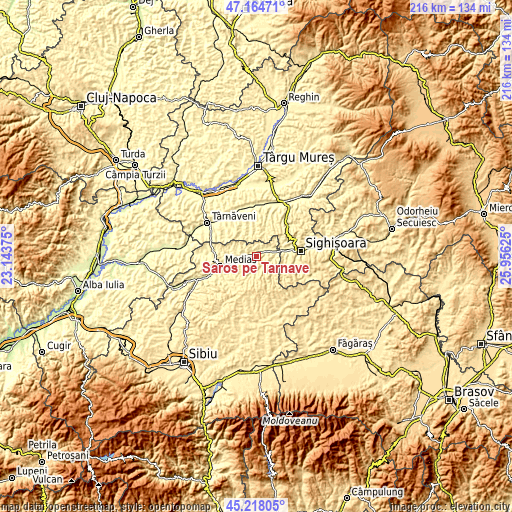
| \ | Map #1 | Topo.Map |
| Scale [m] | 306..520 m | × |
| Scale [ft] | 1004..1706 ft | × |
| Average | 388.3 m = 1274 ft | × |
| Width | 6.76 km = 4.2 mi | 216.4 km = 134.5 mi |
| Height | 6.76 km = 4.2 mi | 216.4 km = 134.5 mi |
| ↑Max Latitude | 46.230408° | 47.16471° |
| Latitude at center | 46.2° | 46.2° |
| ↓Min Latitude | 46.169575° | 45.21805° |
| ← Min Longitude | 24.506055° | 23.14375° |
| Longitude center | 24.55° | 24.55° |
| →Max Longitude | 24.593945° | 25.95625° |
Nearby cities:
Cities around Șaroș pe Târnave sort by population:
• Dumbrăveni elevation 349 m
3.9 km,  19°
19°
• Daneş 377 m
11.7 km,  80°
80°
• Aţel 348 m
8.5 km,  229°
229°
• Dârlos 294 m
11.7 km,  260°
260°
• Laslea 333 m
7.9 km, 76°
• Brateiu 339 m
10.9 km,  250°
250°
• Biertan 380 m
7.8 km,  199°
199°
• Hoghilag 326 m
6.3 km,  54°
54°
• Viişoara 445 m
10 km, 22°
• Seleuș 343 m
12.1 km,  66°
66°
• Mălâncrav 433 m
12.5 km,  142°
142°
• Alma 322 m
5.6 km,  285°
285°
Multilingual:
 En español:
Șaroș pe Târnave elevación 407 m.
 En France:
Șaroș pe Târnave élévation 407 m.
 Auf Deutsch:
Șaroș pe Târnave höhe über dem Meeresspiegel ist 407 m.

Sources and notes:
- [note 1] Map square and city borders are not equal. Map elevation data is calculated only from area inside that square.
- [src 1] Elevation data from geonames database provided with same terms of usage.
- [src 2] The elevation map of Șaroș pe Târnave is generated using elevation data from NASA's 3 arcsec (90m) resolution SRTM data.
- [src 3] Base (background) map © OpenStreetMap contributors tiles are generated by Geofabrik and OpenTopoMap.
Copyright & License:
This Șaroș pe Târnave Elevation Map is licensed under CC BY-SA. You may reuse any part from this page, if you give a proper credit by linking to this URL:
 More info on terms of use page.