Viişoara elevation
Viişoara (Mureş, Comuna Viişoara), Romania elevation is 445 meters and Viişoara elevation in feet is 1460 ft above sea level [src 1]. Viişoara is a seat of a second-order administrative division (feature code) with elevation that is 193 meters (633 ft) bigger than average city elevation in Romania.
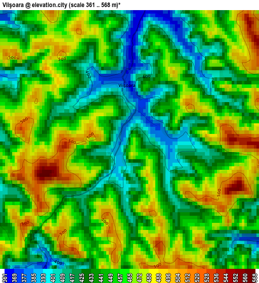
Below is the Elevation map of Viişoara, which displays elevation range with different colors. Scale of the first map is from 361 to 568 m (1184 to 1864 ft) with average elevation of 450.2 meters (=1477 ft) [note 1]
These maps also provides idea of topography and contour of this city, they are displayed at different zoom levels. More info about maps, scale and edge coordinates you can find below images.
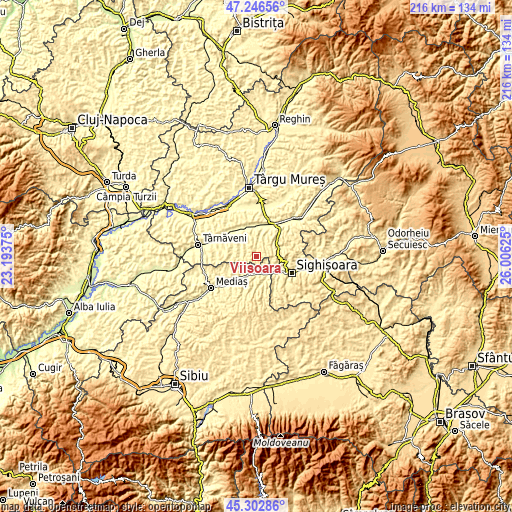
| \ | Map #1 | Topo.Map |
| Scale [m] | 361..568 m | × |
| Scale [ft] | 1184..1864 ft | × |
| Average | 450.2 m = 1477 ft | × |
| Width | 6.75 km = 4.2 mi | 216.1 km = 134.3 mi |
| Height | 6.75 km = 4.2 mi | 216.1 km = 134.3 mi |
| ↑Max Latitude | 46.313692° | 47.24656° |
| Latitude at center | 46.28333° | 46.28333° |
| ↓Min Latitude | 46.252951° | 45.30286° |
| ← Min Longitude | 24.556055° | 23.19375° |
| Longitude center | 24.6° | 24.6° |
| →Max Longitude | 24.643945° | 26.00625° |
Nearby cities:
Cities around Viişoara sort by population:
• Dumbrăveni elevation 349 m
6.1 km,  204°
204°
• Daneş 377 m
10.7 km,  133°
133°
• Bahnea 332 m
12.9 km,  315°
315°
• Laslea 333 m
8.3 km,  152°
152°
• Nadeş 431 m
10.9 km,  70°
70°
• Suplac 347 m
12.8 km,  330°
330°
• Hoghilag 326 m
5.7 km,  167°
167°
• Șaroș pe Târnave 407 m
10 km, 202°
• Seleuș 343 m
8.5 km,  121°
121°
• Coroisânmartin 312 m
13 km,  0°
0°
• Zagăr 349 m
7.5 km,  9°
9°
• Alma 322 m
12 km,  229°
229°
Multilingual:
 En español:
Viişoara elevación 445 m.
 En France:
Viişoara élévation 445 m.
 Auf Deutsch:
Viişoara höhe über dem Meeresspiegel ist 445 m.

Sources and notes:
- [note 1] Map square and city borders are not equal. Map elevation data is calculated only from area inside that square.
- [src 1] Elevation data from geonames database provided with same terms of usage.
- [src 2] The elevation map of Viişoara is generated using elevation data from NASA's 3 arcsec (90m) resolution SRTM data.
- [src 3] Base (background) map © OpenStreetMap contributors tiles are generated by Geofabrik and OpenTopoMap.
Copyright & License:
This Viişoara Elevation Map is licensed under CC BY-SA. You may reuse any part from this page, if you give a proper credit by linking to this URL:
 More info on terms of use page.