Șupitca elevation
Șupitca (Botoşani, Comuna Coşula), Romania elevation is 143 meters and Șupitca elevation in feet is 469 ft above sea level [src 1]. Șupitca is a populated place (feature code) with elevation that is 109 meters (358 ft) smaller than average city elevation in Romania.
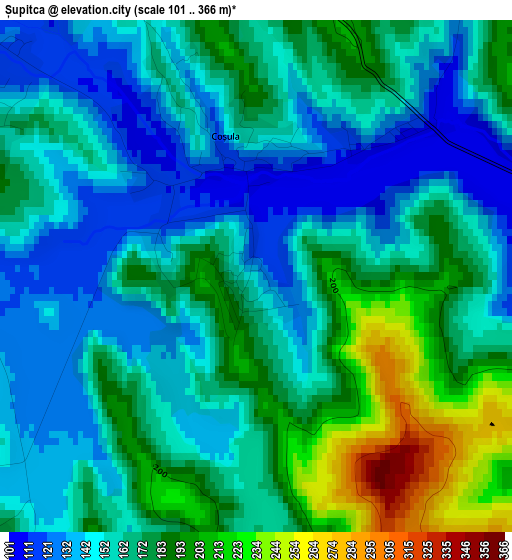
Below is the Elevation map of Șupitca, which displays elevation range with different colors. Scale of the first map is from 101 to 366 m (331 to 1201 ft) with average elevation of 165 meters (=541 ft) [note 1]
These maps also provides idea of topography and contour of this city, they are displayed at different zoom levels. More info about maps, scale and edge coordinates you can find below images.
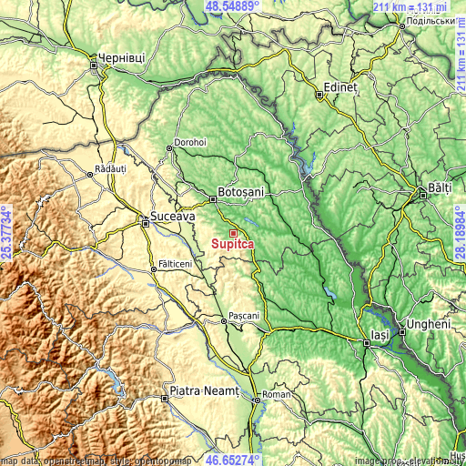
| \ | Map #1 | Topo.Map |
| Scale [m] | 101..366 m | × |
| Scale [ft] | 331..1201 ft | × |
| Average | 165 m = 541 ft | × |
| Width | 6.59 km = 4.1 mi | 210.8 km = 131 mi |
| Height | 6.59 km = 4.1 mi | 210.8 km = 131 mi |
| ↑Max Latitude | 47.639029° | 48.54889° |
| Latitude at center | 47.60941° | 47.60941° |
| ↓Min Latitude | 47.579775° | 46.65274° |
| ← Min Longitude | 26.739645° | 25.37734° |
| Longitude center | 26.78359° | 26.78359° |
| →Max Longitude | 26.827535° | 28.18984° |
Nearby cities:
Cities around Șupitca sort by population:
• Storeşti elevation 164 m
9.1 km,  136°
136°
• Copălău 104 m
3.8 km,  77°
77°
• Băluşeni 96 m
6.5 km,  10°
10°
• Cristeşti 127 m
4.6 km,  305°
305°
• Nicolae Bălcescu 117 m
9.7 km,  119°
119°
• Poiana 127 m
7.8 km,  129°
129°
• Draxini 163 m
5.1 km,  28°
28°
• Oneaga 203 m
5.3 km,  226°
226°
• Sulița 112 m
10.9 km,  65°
65°
• Coșula 142 m
1.9 km,  347°
347°
• Orășeni-Deal 186 m
10.9 km, 312°
• Flămânzi 164 m
9.1 km, 136°
Multilingual:
 En español:
Șupitca elevación 143 m.
 En France:
Șupitca élévation 143 m.


Sources and notes:
- [note 1] Map square and city borders are not equal. Map elevation data is calculated only from area inside that square.
- [src 1] Elevation data from geonames database provided with same terms of usage.
- [src 2] The elevation map of Șupitca is generated using elevation data from NASA's 3 arcsec (90m) resolution SRTM data.
- [src 3] Base (background) map © OpenStreetMap contributors tiles are generated by Geofabrik and OpenTopoMap.
Copyright & License:
This Șupitca Elevation Map is licensed under CC BY-SA. You may reuse any part from this page, if you give a proper credit by linking to this URL:
 More info on terms of use page.