Sulița elevation
Sulița (Botoşani, Comuna Suliţa), Romania elevation is 112 meters and Sulița elevation in feet is 367 ft above sea level [src 1]. Sulița is a seat of a second-order administrative division (feature code) with elevation that is 140 meters (459 ft) smaller than average city elevation in Romania.
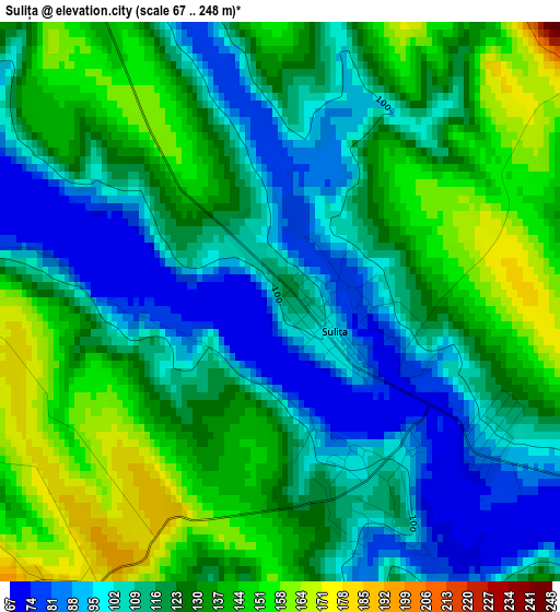
Below is the Elevation map of Sulița, which displays elevation range with different colors. Scale of the first map is from 67 to 248 m (220 to 814 ft) with average elevation of 121.9 meters (=400 ft) [note 1]
These maps also provides idea of topography and contour of this city, they are displayed at different zoom levels. More info about maps, scale and edge coordinates you can find below images.
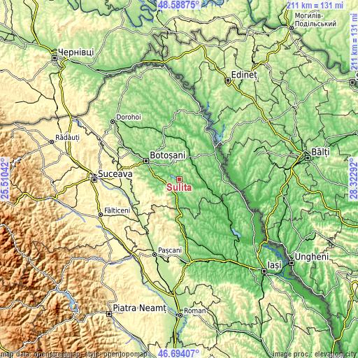
| \ | Map #1 | Topo.Map |
| Scale [m] | 67..248 m | × |
| Scale [ft] | 220..814 ft | × |
| Average | 121.9 m = 400 ft | × |
| Width | 6.58 km = 4.1 mi | 210.7 km = 130.9 mi |
| Height | 6.58 km = 4.1 mi | 210.7 km = 130.9 mi |
| ↑Max Latitude | 47.679596° | 48.58875° |
| Latitude at center | 47.65° | 47.65° |
| ↓Min Latitude | 47.620388° | 46.69407° |
| ← Min Longitude | 26.872725° | 25.51042° |
| Longitude center | 26.91667° | 26.91667° |
| →Max Longitude | 26.960615° | 28.32292° |
Nearby cities:
Cities around Sulița sort by population:
• Copălău elevation 104 m
7.3 km,  239°
239°
• Băluşeni 96 m
8.9 km,  281°
281°
• Lunca 105 m
6.2 km,  126°
126°
• Nicolae Bălcescu 117 m
9.4 km,  189°
189°
• Zlătunoaia 169 m
6.8 km,  89°
89°
• Poiana 127 m
10.3 km,  202°
202°
• Draxini 163 m
7.5 km,  270°
270°
• Dracșani 110 m
2.5 km,  155°
155°
• Coșula 142 m
10.7 km,  255°
255°
• Ionășeni 194 m
10.6 km,  32°
32°
• Stroiești 101 m
5.7 km,  140°
140°
• Blândeşti 161 m
6.7 km,  326°
326°
Multilingual:
 En español:
Sulița elevación 112 m.
 En France:
Sulița élévation 112 m.


Sources and notes:
- [note 1] Map square and city borders are not equal. Map elevation data is calculated only from area inside that square.
- [src 1] Elevation data from geonames database provided with same terms of usage.
- [src 2] The elevation map of Sulița is generated using elevation data from NASA's 3 arcsec (90m) resolution SRTM data.
- [src 3] Base (background) map © OpenStreetMap contributors tiles are generated by Geofabrik and OpenTopoMap.
Copyright & License:
This Sulița Elevation Map is licensed under CC BY-SA. You may reuse any part from this page, if you give a proper credit by linking to this URL:
 More info on terms of use page.