Poiana elevation
Poiana (Botoşani, Oraş Flãmânzi), Romania elevation is 127 meters and Poiana elevation in feet is 417 ft above sea level [src 1]. Poiana is a populated place (feature code) with elevation that is 125 meters (410 ft) smaller than average city elevation in Romania.
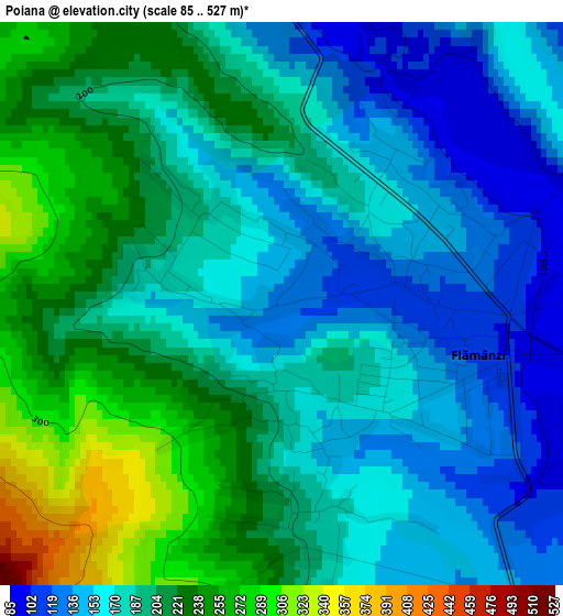
Below is the Elevation map of Poiana, which displays elevation range with different colors. Scale of the first map is from 85 to 527 m (279 to 1729 ft) with average elevation of 189.3 meters (=621 ft) [note 1]
These maps also provides idea of topography and contour of this city, they are displayed at different zoom levels. More info about maps, scale and edge coordinates you can find below images.
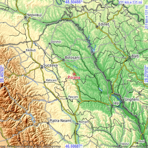
| \ | Map #1 | Topo.Map |
| Scale [m] | 85..527 m | × |
| Scale [ft] | 279..1729 ft | × |
| Average | 189.3 m = 621 ft | × |
| Width | 6.59 km = 4.1 mi | 211 km = 131.1 mi |
| Height | 6.59 km = 4.1 mi | 211 km = 131.1 mi |
| ↑Max Latitude | 47.594004° | 48.50466° |
| Latitude at center | 47.56436° | 47.56436° |
| ↓Min Latitude | 47.534699° | 46.60687° |
| ← Min Longitude | 26.819925° | 25.45762° |
| Longitude center | 26.86387° | 26.86387° |
| →Max Longitude | 26.907815° | 28.27012° |
Nearby cities:
Cities around Poiana sort by population:
• Storeşti elevation 164 m
1.6 km,  172°
172°
• Copălău 104 m
6.3 km,  338°
338°
• Frumuşica 139 m
4.4 km,  141°
141°
• Nicolae Bălcescu 117 m
2.4 km,  84°
84°
• Vlădeni-Deal 173 m
4.7 km, 171°
• Dracșani 110 m
8.8 km,  34°
34°
• Coșula 142 m
9.4 km,  316°
316°
• Poiana 323 m
7.9 km,  180°
180°
• Rădeni 157 m
6.2 km,  159°
159°
• Șupitca 143 m
7.8 km,  309°
309°
• Stroiești 101 m
9.2 km,  56°
56°
• Flămânzi 164 m
1.6 km, 172°
Multilingual:
 En español:
Poiana elevación 127 m.
 En France:
Poiana élévation 127 m.


Sources and notes:
- [note 1] Map square and city borders are not equal. Map elevation data is calculated only from area inside that square.
- [src 1] Elevation data from geonames database provided with same terms of usage.
- [src 2] The elevation map of Poiana is generated using elevation data from NASA's 3 arcsec (90m) resolution SRTM data.
- [src 3] Base (background) map © OpenStreetMap contributors tiles are generated by Geofabrik and OpenTopoMap.
Copyright & License:
This Poiana Elevation Map is licensed under CC BY-SA. You may reuse any part from this page, if you give a proper credit by linking to this URL:
 More info on terms of use page.