Tansa elevation
Tansa (Iaşi, Comuna Belceşti), Romania elevation is 102 meters and Tansa elevation in feet is 335 ft above sea level [src 1]. Tansa is a populated place (feature code) with elevation that is 150 meters (492 ft) smaller than average city elevation in Romania.
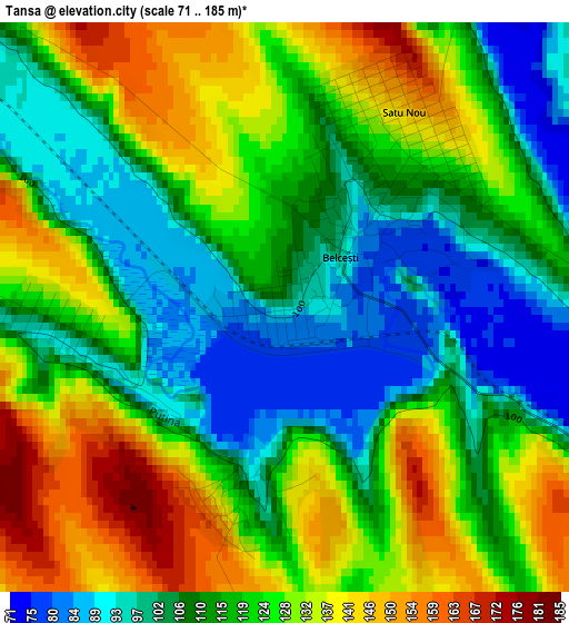
Below is the Elevation map of Tansa, which displays elevation range with different colors. Scale of the first map is from 71 to 185 m (233 to 607 ft) with average elevation of 119.2 meters (=391 ft) [note 1]
These maps also provides idea of topography and contour of this city, they are displayed at different zoom levels. More info about maps, scale and edge coordinates you can find below images.
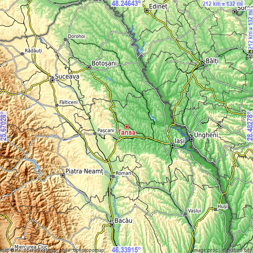
| \ | Map #1 | Topo.Map |
| Scale [m] | 71..185 m | × |
| Scale [ft] | 233..607 ft | × |
| Average | 119.2 m = 391 ft | × |
| Width | 6.63 km = 4.1 mi | 212.1 km = 131.8 mi |
| Height | 6.63 km = 4.1 mi | 212.1 km = 131.8 mi |
| ↑Max Latitude | 47.331183° | 48.24643° |
| Latitude at center | 47.30139° | 47.30139° |
| ↓Min Latitude | 47.27158° | 46.33915° |
| ← Min Longitude | 27.032585° | 25.67028° |
| Longitude center | 27.07653° | 27.07653° |
| →Max Longitude | 27.120475° | 28.48278° |
Nearby cities:
Cities around Tansa sort by population:
• Belceşti elevation 90 m
0.5 km,  106°
106°
• Cotnari 107 m
8.9 km,  307°
307°
• Bălţaţi 86 m
10.9 km,  149°
149°
• Cepleniţa 160 m
10.2 km,  333°
333°
• Coarnele Caprei 103 m
9.3 km,  10°
10°
• Satu Nou 150 m
2.7 km,  32°
32°
• Boureni 134 m
8.5 km,  241°
241°
• Hodora 103 m
5.8 km, 312°
• Liteni 128 m
2.9 km,  270°
270°
• Munteni 106 m
4.9 km,  71°
71°
• Războieni 106 m
9.5 km,  191°
191°
• Balș 114 m
7.4 km, 265°
Multilingual:
 En español:
Tansa elevación 102 m.
 En France:
Tansa élévation 102 m.


Sources and notes:
- [note 1] Map square and city borders are not equal. Map elevation data is calculated only from area inside that square.
- [src 1] Elevation data from geonames database provided with same terms of usage.
- [src 2] The elevation map of Tansa is generated using elevation data from NASA's 3 arcsec (90m) resolution SRTM data.
- [src 3] Base (background) map © OpenStreetMap contributors tiles are generated by Geofabrik and OpenTopoMap.
Copyright & License:
This Tansa Elevation Map is licensed under CC BY-SA. You may reuse any part from this page, if you give a proper credit by linking to this URL:
 More info on terms of use page.