Cotnari elevation
Cotnari (Iaşi, Comuna Cotnari), Romania elevation is 107 meters and Cotnari elevation in feet is 351 ft above sea level [src 1]. Cotnari is a seat of a second-order administrative division (feature code) with elevation that is 145 meters (476 ft) smaller than average city elevation in Romania.
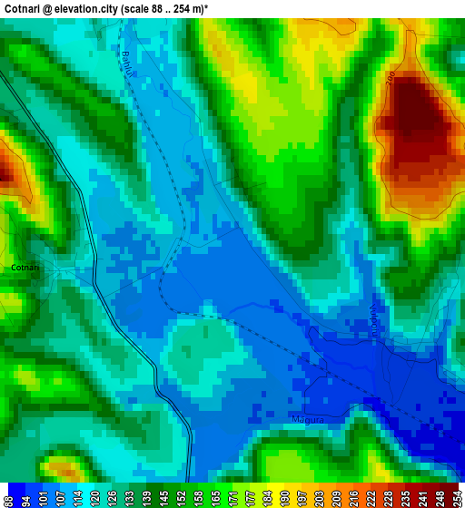
Below is the Elevation map of Cotnari, which displays elevation range with different colors. Scale of the first map is from 88 to 254 m (289 to 833 ft) with average elevation of 137 meters (=449 ft) [note 1]
These maps also provides idea of topography and contour of this city, they are displayed at different zoom levels. More info about maps, scale and edge coordinates you can find below images.
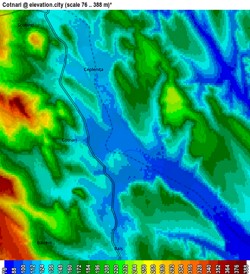
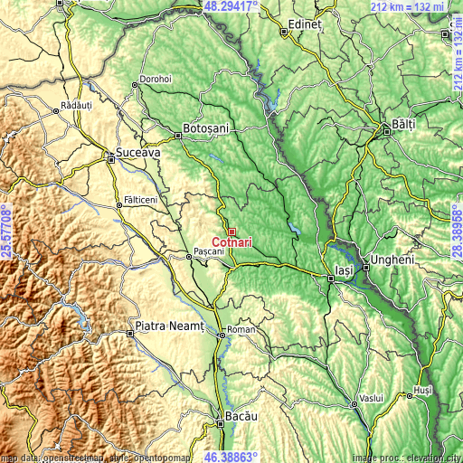
| \ | Map #1 | Map #2 | Topo.Map |
| Scale [m] | 88..254 m | 76..388 m | × |
| Scale [ft] | 289..833 ft | 249..1273 ft | × |
| Average | 137 m = 449 ft | 159.5 m = 523 ft | × |
| Width | 6.62 km = 4.1 mi | 13.24 km = 8.2 mi | 211.9 km = 131.7 mi |
| Height | 6.62 km = 4.1 mi | 13.24 km = 8.2 mi | 211.9 km = 131.7 mi |
| ↑Max Latitude | 47.379765° | 47.409514° | 48.29417° |
| Latitude at center | 47.35° | 47.35° | 47.35° |
| ↓Min Latitude | 47.320218° | 47.290419° | 46.38863° |
| ← Min Longitude | 26.939385° | 26.895439° | 25.57708° |
| Longitude center | 26.98333° | 26.98333° | 26.98333° |
| →Max Longitude | 27.027275° | 27.071221° | 28.38958° |
Nearby cities:
Cities around Cotnari sort by population:
• Scobinţi elevation 125 m
5.3 km,  314°
314°
• Cepleniţa 160 m
4.5 km,  34°
34°
• Cârjoaia 168 m
5.7 km,  259°
259°
• Buhalnița 184 m
6 km,  302°
302°
• Cucuteni 282 m
8.3 km,  206°
206°
• Hodora 103 m
3.1 km,  117°
117°
• Liteni 128 m
6.8 km,  142°
142°
• Bădeni 125 m
6.7 km,  337°
337°
• Fetești 206 m
8.7 km,  319°
319°
• Balș 114 m
6 km,  183°
183°
• Poiana Mărului 239 m
7.6 km, 295°
• Tansa 102 m
8.9 km,  127°
127°
Multilingual:
 En español:
Cotnari elevación 107 m.
 En France:
Cotnari élévation 107 m.


Sources and notes:
- [note 1] Map square and city borders are not equal. Map elevation data is calculated only from area inside that square.
- [src 1] Elevation data from geonames database provided with same terms of usage.
- [src 2] The elevation map of Cotnari is generated using elevation data from NASA's 3 arcsec (90m) resolution SRTM data.
- [src 3] Base (background) map © OpenStreetMap contributors tiles are generated by Geofabrik and OpenTopoMap.
Copyright & License:
This Cotnari Elevation Map is licensed under CC BY-SA. You may reuse any part from this page, if you give a proper credit by linking to this URL:
 More info on terms of use page.