Bălţaţi elevation
Bălţaţi (Iaşi, Comuna Bălţaţi), Romania elevation is 86 meters and Bălţaţi elevation in feet is 282 ft above sea level [src 1]. Bălţaţi is a seat of a second-order administrative division (feature code) with elevation that is 166 meters (545 ft) smaller than average city elevation in Romania.
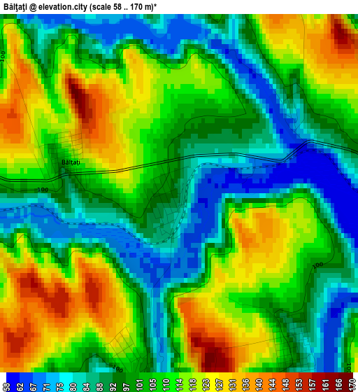
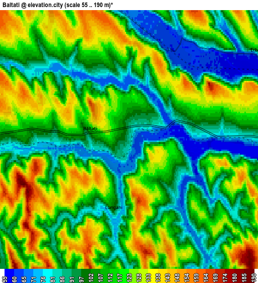
Below is the Elevation map of Bălţaţi, which displays elevation range with different colors. Scale of the first map is from 58 to 170 m (190 to 558 ft) with average elevation of 104.2 meters (=342 ft) [note 1]
These maps also provides idea of topography and contour of this city, they are displayed at different zoom levels. More info about maps, scale and edge coordinates you can find below images.
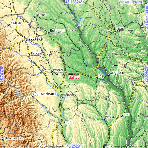
| \ | Map #1 | Map #2 | Topo.Map |
| Scale [m] | 58..170 m | 55..190 m | × |
| Scale [ft] | 190..558 ft | 180..623 ft | × |
| Average | 104.2 m = 342 ft | 110 m = 361 ft | × |
| Width | 6.64 km = 4.1 mi | 13.28 km = 8.3 mi | 212.4 km = 132 mi |
| Height | 6.64 km = 4.1 mi | 13.28 km = 8.3 mi | 212.4 km = 132 mi |
| ↑Max Latitude | 47.24651° | 47.276334° | 48.16324° |
| Latitude at center | 47.21667° | 47.21667° | 47.21667° |
| ↓Min Latitude | 47.186813° | 47.156939° | 46.2529° |
| ← Min Longitude | 27.106055° | 27.062109° | 25.74375° |
| Longitude center | 27.15° | 27.15° | 27.15° |
| →Max Longitude | 27.193945° | 27.237891° | 28.55625° |
Nearby cities:
Cities around Bălţaţi sort by population:
• Podu Iloaiei elevation 84 m
8.8 km,  90°
90°
• Erbiceni 128 m
8.4 km,  48°
48°
• Lungani 109 m
3.7 km,  180°
180°
• Popeşti 161 m
9.7 km,  139°
139°
• Brăeşti 102 m
8.3 km,  207°
207°
• Crucea 135 m
5.9 km,  164°
164°
• Cristești 110 m
8 km,  220°
220°
• Războieni 106 m
7.5 km,  270°
270°
• Zmeu 81 m
3.6 km, 141°
• Goești 110 m
6.8 km,  188°
188°
• Budăi 74 m
5.5 km, 88°
• Ion Neculce 117 m
7.5 km,  258°
258°
Multilingual:
 En español:
Bălţaţi elevación 86 m.
 En France:
Bălţaţi élévation 86 m.


Sources and notes:
- [note 1] Map square and city borders are not equal. Map elevation data is calculated only from area inside that square.
- [src 1] Elevation data from geonames database provided with same terms of usage.
- [src 2] The elevation map of Bălţaţi is generated using elevation data from NASA's 3 arcsec (90m) resolution SRTM data.
- [src 3] Base (background) map © OpenStreetMap contributors tiles are generated by Geofabrik and OpenTopoMap.
Copyright & License:
This Bălţaţi Elevation Map is licensed under CC BY-SA. You may reuse any part from this page, if you give a proper credit by linking to this URL:
 More info on terms of use page.