Târnava elevation
Târnava (Teleorman, Comuna Botoroaga), Romania elevation is 79 meters and Târnava elevation in feet is 259 ft above sea level [src 1]. Târnava is a populated place (feature code) with elevation that is 173 meters (568 ft) smaller than average city elevation in Romania.
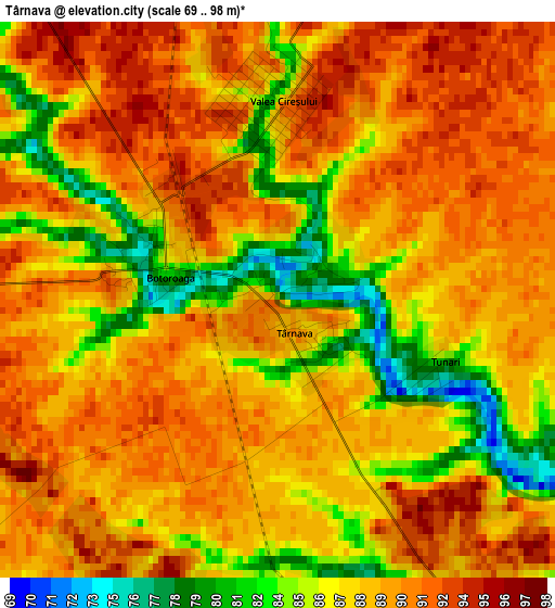
Below is the Elevation map of Târnava, which displays elevation range with different colors. Scale of the first map is from 69 to 98 m (226 to 322 ft) with average elevation of 88.4 meters (=290 ft) [note 1]
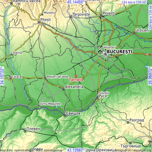
These maps also provides idea of topography and contour of this city, they are displayed at different zoom levels. More info about maps, scale and edge coordinates you can find below images.
| \ | Map #1 | Topo.Map |
| Scale [m] | 69..98 m | × |
| Scale [ft] | 226..322 ft | × |
| Average | 88.4 m = 290 ft | × |
| Width | 7.01 km = 4.4 mi | 224.4 km = 139.4 mi |
| Height | 7.01 km = 4.4 mi | 224.4 km = 139.4 mi |
| ↑Max Latitude | 44.175926° | 45.14488° |
| Latitude at center | 44.1444° | 44.1444° |
| ↓Min Latitude | 44.112857° | 43.12667° |
| ← Min Longitude | 25.519525° | 24.15722° |
| Longitude center | 25.56347° | 25.56347° |
| →Max Longitude | 25.607415° | 26.96972° |
Nearby cities:
Cities around Târnava sort by population:
• Botoroaga elevation 86 m
1.6 km,  286°
286°
• Drăgăneşti-Vlaşca 70 m
5.5 km,  150°
150°
• Ciuani 76 m
12.1 km,  34°
34°
• Răsuceni 71 m
9.9 km,  126°
126°
• Valea Cireșului 89 m
2.5 km,  1°
1°
• Merenii de Jos 76 m
11.7 km, 33°
• Moșteni 99 m
7.4 km,  323°
323°
• Crevenicu 82 m
10.9 km,  10°
10°
• Merenii de Sus 86 m
10.4 km, 26°
• Letca Veche 94 m
11.6 km,  58°
58°
• Merișani 90 m
13.4 km,  256°
256°
• Bujoreni 69 m
6.4 km,  118°
118°
Multilingual:
 En español:
Târnava elevación 79 m.
 En France:
Târnava élévation 79 m.


Sources and notes:
- [note 1] Map square and city borders are not equal. Map elevation data is calculated only from area inside that square.
- [src 1] Elevation data from geonames database provided with same terms of usage.
- [src 2] The elevation map of Târnava is generated using elevation data from NASA's 3 arcsec (90m) resolution SRTM data.
- [src 3] Base (background) map © OpenStreetMap contributors tiles are generated by Geofabrik and OpenTopoMap.
Copyright & License:
This Târnava Elevation Map is licensed under CC BY-SA. You may reuse any part from this page, if you give a proper credit by linking to this URL:
 More info on terms of use page.