Merișani elevation
Merișani (Teleorman, Comuna Băbăiţa), Romania elevation is 90 meters and Merișani elevation in feet is 295 ft above sea level [src 1]. Merișani is a populated place (feature code) with elevation that is 162 meters (531 ft) smaller than average city elevation in Romania.
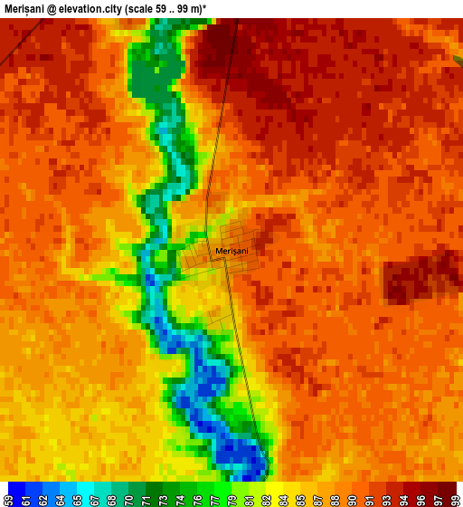
Below is the Elevation map of Merișani, which displays elevation range with different colors. Scale of the first map is from 59 to 99 m (194 to 325 ft) with average elevation of 87.5 meters (=287 ft) [note 1]
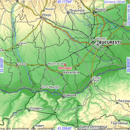
These maps also provides idea of topography and contour of this city, they are displayed at different zoom levels. More info about maps, scale and edge coordinates you can find below images.
| \ | Map #1 | Topo.Map |
| Scale [m] | 59..99 m | × |
| Scale [ft] | 194..325 ft | × |
| Average | 87.5 m = 287 ft | × |
| Width | 7.02 km = 4.4 mi | 224.5 km = 139.5 mi |
| Height | 7.02 km = 4.4 mi | 224.5 km = 139.5 mi |
| ↑Max Latitude | 44.148231° | 45.11764° |
| Latitude at center | 44.11669° | 44.11669° |
| ↓Min Latitude | 44.085132° | 43.09849° |
| ← Min Longitude | 25.355855° | 23.99355° |
| Longitude center | 25.3998° | 25.3998° |
| →Max Longitude | 25.443745° | 26.80605° |
Nearby cities:
Cities around Merișani sort by population:
• Orbeasca de Sus elevation 70 m
7.6 km,  299°
299°
• Botoroaga 86 m
12.1 km,  73°
73°
• Băbăiţa 93 m
5.7 km,  346°
346°
• Olteni 75 m
11.9 km,  308°
308°
• Vităneşti 45 m
13 km,  174°
174°
• Gălăţeni 105 m
11.8 km,  340°
340°
• Măgura 65 m
9.3 km,  179°
179°
• Orbeasca de Jos 65 m
5.6 km,  275°
275°
• Lăceni 60 m
6.4 km,  236°
236°
• Frăsinet 80 m
7.2 km, 348°
• Moșteni 99 m
12.5 km,  43°
43°
• Guruieni 62 m
6.5 km, 182°
Multilingual:
 En español:
Merișani elevación 90 m.
 En France:
Merișani élévation 90 m.


Sources and notes:
- [note 1] Map square and city borders are not equal. Map elevation data is calculated only from area inside that square.
- [src 1] Elevation data from geonames database provided with same terms of usage.
- [src 2] The elevation map of Merișani is generated using elevation data from NASA's 3 arcsec (90m) resolution SRTM data.
- [src 3] Base (background) map © OpenStreetMap contributors tiles are generated by Geofabrik and OpenTopoMap.
Copyright & License:
This Merișani Elevation Map is licensed under CC BY-SA. You may reuse any part from this page, if you give a proper credit by linking to this URL:
 More info on terms of use page.