Topliceni elevation
Topliceni (Buzău, Comuna Topliceni), Romania elevation is 201 meters and Topliceni elevation in feet is 659 ft above sea level [src 1]. Topliceni is a seat of a second-order administrative division (feature code) with elevation that is 51 meters (167 ft) smaller than average city elevation in Romania.
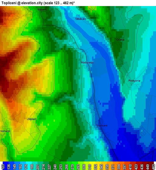
Below is the Elevation map of Topliceni, which displays elevation range with different colors. Scale of the first map is from 123 to 462 m (404 to 1516 ft) with average elevation of 237.3 meters (=779 ft) [note 1]
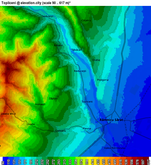
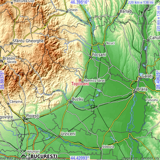
These maps also provides idea of topography and contour of this city, they are displayed at different zoom levels. More info about maps, scale and edge coordinates you can find below images.
| \ | Map #1 | Map #2 | Topo.Map |
| Scale [m] | 123..462 m | 90..617 m | × |
| Scale [ft] | 404..1516 ft | 295..2024 ft | × |
| Average | 237.3 m = 779 ft | 246.8 m = 810 ft | × |
| Width | 6.86 km = 4.3 mi | 13.72 km = 8.5 mi | 219.5 km = 136.4 mi |
| Height | 6.86 km = 4.3 mi | 13.72 km = 8.5 mi | 219.5 km = 136.4 mi |
| ↑Max Latitude | 45.447509° | 45.478331° | 46.39516° |
| Latitude at center | 45.41667° | 45.41667° | 45.41667° |
| ↓Min Latitude | 45.385814° | 45.354942° | 44.42093° |
| ← Min Longitude | 26.956055° | 26.912109° | 25.59375° |
| Longitude center | 27° | 27° | 27° |
| →Max Longitude | 27.043945° | 27.087891° | 28.40625° |
Nearby cities:
Cities around Topliceni sort by population:
• Râmnicu Sărat elevation 130 m
5.4 km,  133°
133°
• Podgoria 151 m
1.3 km,  90°
90°
• Oreavu 151 m
5.7 km,  161°
161°
• Grebănu 251 m
4.5 km,  215°
215°
• Valea Râmnicului 117 m
6.7 km,  150°
150°
• Coțatcu 276 m
5.7 km,  11°
11°
• Racoviţeni 324 m
9.6 km,  234°
234°
• Plevna 182 m
4.4 km,  166°
166°
• Rubla 100 m
9.2 km,  140°
140°
• Murgeşti 292 m
9.3 km,  258°
258°
• Băbeni 252 m
3.7 km,  333°
333°
• Dedulești 198 m
6.5 km,  336°
336°
Multilingual:
 En español:
Topliceni elevación 201 m.
 En France:
Topliceni élévation 201 m.
 Auf Deutsch:
Topliceni höhe über dem Meeresspiegel ist 201 m.

Sources and notes:
- [note 1] Map square and city borders are not equal. Map elevation data is calculated only from area inside that square.
- [src 1] Elevation data from geonames database provided with same terms of usage.
- [src 2] The elevation map of Topliceni is generated using elevation data from NASA's 3 arcsec (90m) resolution SRTM data.
- [src 3] Base (background) map © OpenStreetMap contributors tiles are generated by Geofabrik and OpenTopoMap.
Copyright & License:
This Topliceni Elevation Map is licensed under CC BY-SA. You may reuse any part from this page, if you give a proper credit by linking to this URL:
 More info on terms of use page.