Râmnicu Sărat elevation
Râmnicu Sărat (Buzău, Municipiul Râmnicu Sãrat), Romania elevation is 130 meters and Râmnicu Sărat elevation in feet is 427 ft above sea level [src 1]. Râmnicu Sărat is a seat of a second-order administrative division (feature code) with elevation that is 122 meters (400 ft) smaller than average city elevation in Romania.
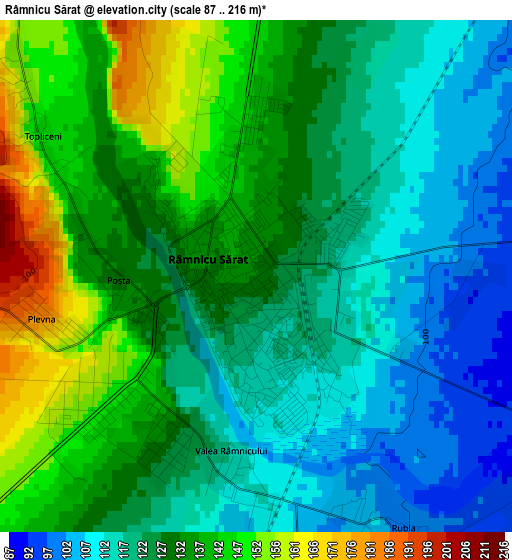
Below is the Elevation map of Râmnicu Sărat, which displays elevation range with different colors. Scale of the first map is from 87 to 216 m (285 to 709 ft) with average elevation of 127.4 meters (=418 ft) [note 1]
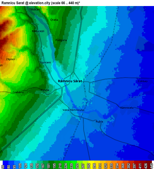
These maps also provides idea of topography and contour of this city, they are displayed at different zoom levels. More info about maps, scale and edge coordinates you can find below images.
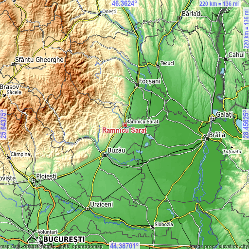
| \ | Map #1 | Map #2 | Topo.Map |
| Scale [m] | 87..216 m | 66..440 m | × |
| Scale [ft] | 285..709 ft | 217..1444 ft | × |
| Average | 127.4 m = 418 ft | 141.7 m = 465 ft | × |
| Width | 6.86 km = 4.3 mi | 13.73 km = 8.5 mi | 219.6 km = 136.5 mi |
| Height | 6.86 km = 4.3 mi | 13.73 km = 8.5 mi | 219.6 km = 136.5 mi |
| ↑Max Latitude | 45.414187° | 45.445027° | 46.3624° |
| Latitude at center | 45.38333° | 45.38333° | 45.38333° |
| ↓Min Latitude | 45.352456° | 45.321565° | 44.38701° |
| ← Min Longitude | 27.006055° | 26.962109° | 25.64375° |
| Longitude center | 27.05° | 27.05° | 27.05° |
| →Max Longitude | 27.093945° | 27.137891° | 28.45625° |
Nearby cities:
Cities around Râmnicu Sărat sort by population:
• Ziduri elevation 70 m
9.6 km,  164°
164°
• Topliceni 201 m
5.4 km,  313°
313°
• Podgoria 151 m
4.5 km,  324°
324°
• Râmnicelu 86 m
5.3 km,  114°
114°
• Oreavu 151 m
2.7 km,  231°
231°
• Grebănu 251 m
6.5 km,  270°
270°
• Valea Râmnicului 117 m
2.2 km,  196°
196°
• Coțatcu 276 m
9.6 km,  343°
343°
• Plevna 182 m
2.9 km,  258°
258°
• Voetin 71 m
10.1 km,  48°
48°
• Rubla 100 m
3.9 km,  149°
149°
• Băbeni 252 m
8.9 km, 321°
Multilingual:
 En español:
Râmnicu Sărat elevación 130 m.
 En France:
Râmnicu Sărat élévation 130 m.
 Auf Deutsch:
Râmnicu Sărat höhe über dem Meeresspiegel ist 130 m.

Sources and notes:
- [note 1] Map square and city borders are not equal. Map elevation data is calculated only from area inside that square.
- [src 1] Elevation data from geonames database provided with same terms of usage.
- [src 2] The elevation map of Râmnicu Sărat is generated using elevation data from NASA's 3 arcsec (90m) resolution SRTM data.
- [src 3] Base (background) map © OpenStreetMap contributors tiles are generated by Geofabrik and OpenTopoMap.
Copyright & License:
This Râmnicu Sărat Elevation Map is licensed under CC BY-SA. You may reuse any part from this page, if you give a proper credit by linking to this URL:
 More info on terms of use page.