Turia elevation
Turia (Covasna, Comuna Turia), Romania elevation is 621 meters and Turia elevation in feet is 2037 ft above sea level [src 1]. Turia is a seat of a second-order administrative division (feature code) with elevation that is 369 meters (1211 ft) bigger than average city elevation in Romania.
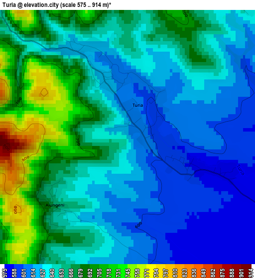
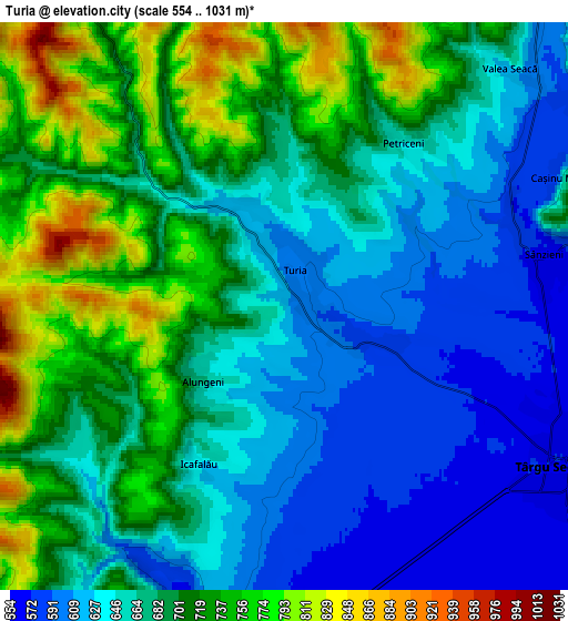
Below is the Elevation map of Turia, which displays elevation range with different colors. Scale of the first map is from 575 to 914 m (1886 to 2999 ft) with average elevation of 650.8 meters (=2135 ft) [note 1]
These maps also provides idea of topography and contour of this city, they are displayed at different zoom levels. More info about maps, scale and edge coordinates you can find below images.
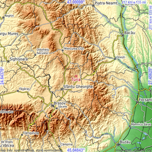
| \ | Map #1 | Map #2 | Topo.Map |
| Scale [m] | 575..914 m | 554..1031 m | × |
| Scale [ft] | 1886..2999 ft | 1818..3383 ft | × |
| Average | 650.8 m = 2135 ft | 680.3 m = 2232 ft | × |
| Width | 6.78 km = 4.2 mi | 13.57 km = 8.4 mi | 217.1 km = 134.9 mi |
| Height | 6.78 km = 4.2 mi | 13.57 km = 8.4 mi | 217.1 km = 134.9 mi |
| ↑Max Latitude | 46.06383° | 46.094313° | 47.00099° |
| Latitude at center | 46.03333° | 46.03333° | 46.03333° |
| ↓Min Latitude | 46.002813° | 45.972279° | 45.04843° |
| ← Min Longitude | 26.006055° | 25.962109° | 24.64375° |
| Longitude center | 26.05° | 26.05° | 26.05° |
| →Max Longitude | 26.093945° | 26.137891° | 27.45625° |
Nearby cities:
Cities around Turia sort by population:
• Târgu Secuiesc elevation 571 m
7.4 km,  119°
119°
• Sânzieni 654 m
6.7 km,  73°
73°
• Cernat 563 m
9.4 km,  187°
187°
• Catalina 551 m
10.7 km,  133°
133°
• Ojdula 589 m
16.4 km,  109°
109°
• Poian 728 m
8.6 km,  64°
64°
• Micfalău 618 m
16.6 km,  277°
277°
• Bixad 688 m
16 km,  297°
297°
• Lunga 560 m
12.6 km,  97°
97°
• Dalnic 577 m
13.2 km,  201°
201°
• Mereni 615 m
15.2 km, 70°
• Estelnic 610 m
14.8 km, 57°
Multilingual:
 En español:
Turia elevación 621 m.
 En France:
Turia élévation 621 m.


Sources and notes:
- [note 1] Map square and city borders are not equal. Map elevation data is calculated only from area inside that square.
- [src 1] Elevation data from geonames database provided with same terms of usage.
- [src 2] The elevation map of Turia is generated using elevation data from NASA's 3 arcsec (90m) resolution SRTM data.
- [src 3] Base (background) map © OpenStreetMap contributors tiles are generated by Geofabrik and OpenTopoMap.
Copyright & License:
This Turia Elevation Map is licensed under CC BY-SA. You may reuse any part from this page, if you give a proper credit by linking to this URL:
 More info on terms of use page.