Micfalău elevation
Micfalău (Covasna, Comuna Micfalău), Romania elevation is 618 meters and Micfalău elevation in feet is 2028 ft above sea level [src 1]. Micfalău is a seat of a second-order administrative division (feature code) with elevation that is 366 meters (1201 ft) bigger than average city elevation in Romania.
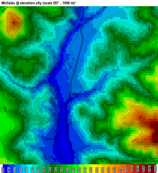
Below is the Elevation map of Micfalău, which displays elevation range with different colors. Scale of the first map is from 557 to 1099 m (1827 to 3606 ft) with average elevation of 702.2 meters (=2304 ft) [note 1]
These maps also provides idea of topography and contour of this city, they are displayed at different zoom levels. More info about maps, scale and edge coordinates you can find below images.
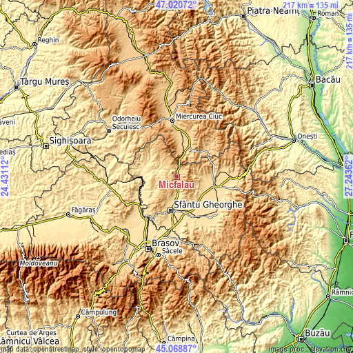
| \ | Map #1 | Topo.Map |
| Scale [m] | 557..1099 m | × |
| Scale [ft] | 1827..3606 ft | × |
| Average | 702.2 m = 2304 ft | × |
| Width | 6.78 km = 4.2 mi | 217 km = 134.8 mi |
| Height | 6.78 km = 4.2 mi | 217 km = 134.8 mi |
| ↑Max Latitude | 46.083909° | 47.02072° |
| Latitude at center | 46.05342° | 46.05342° |
| ↓Min Latitude | 46.022914° | 45.06887° |
| ← Min Longitude | 25.793425° | 24.43112° |
| Longitude center | 25.83737° | 25.83737° |
| →Max Longitude | 25.881315° | 27.24362° |
Nearby cities:
Cities around Micfalău sort by population:
• Malnaş elevation 568 m
4.1 km,  184°
184°
• Băţanii Mari 509 m
12.3 km,  285°
285°
• Turia 621 m
16.6 km,  97°
97°
• Valea Crişului 613 m
16.2 km,  199°
199°
• Ghidfalău 555 m
17.1 km, 176°
• Bodoc 539 m
11.5 km, 175°
• Tuşnad 638 m
17 km,  16°
16°
• Bixad 688 m
5.7 km, 23°
• Băile Tuşnad 845 m
10.8 km,  5°
5°
• Arcuș 574 m
17.6 km, 195°
• Herculian 585 m
13.3 km,  312°
312°
• Tușnadu Nou 654 m
16.1 km, 13°
Multilingual:
 En español:
Micfalău elevación 618 m.
 En France:
Micfalău élévation 618 m.
 Auf Deutsch:
Micfalău höhe über dem Meeresspiegel ist 618 m.

Sources and notes:
- [note 1] Map square and city borders are not equal. Map elevation data is calculated only from area inside that square.
- [src 1] Elevation data from geonames database provided with same terms of usage.
- [src 2] The elevation map of Micfalău is generated using elevation data from NASA's 3 arcsec (90m) resolution SRTM data.
- [src 3] Base (background) map © OpenStreetMap contributors tiles are generated by Geofabrik and OpenTopoMap.
Copyright & License:
This Micfalău Elevation Map is licensed under CC BY-SA. You may reuse any part from this page, if you give a proper credit by linking to this URL:
 More info on terms of use page.