Vişina elevation
Vişina (Dâmboviţa, Comuna Vişina), Romania elevation is 165 meters and Vişina elevation in feet is 541 ft above sea level [src 1]. Vişina is a seat of a second-order administrative division (feature code) with elevation that is 87 meters (285 ft) smaller than average city elevation in Romania.
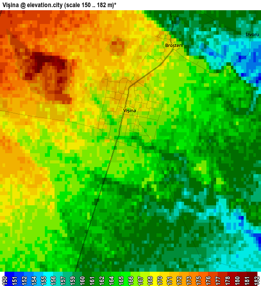
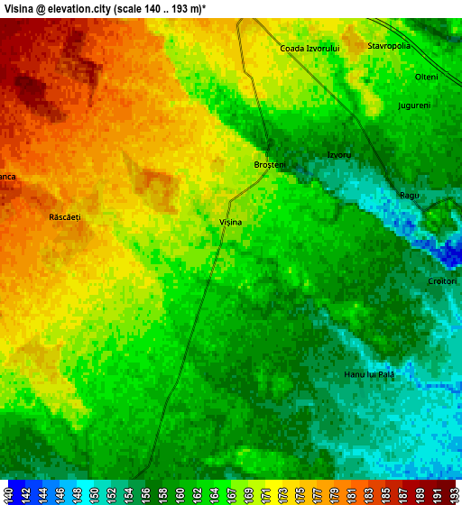
Below is the Elevation map of Vişina, which displays elevation range with different colors. Scale of the first map is from 150 to 182 m (492 to 597 ft) with average elevation of 165.3 meters (=542 ft) [note 1]
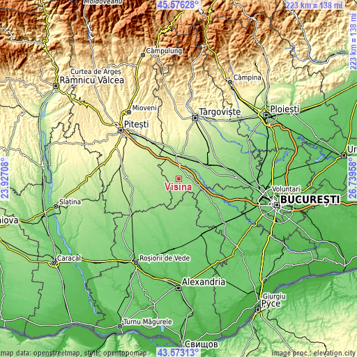
These maps also provides idea of topography and contour of this city, they are displayed at different zoom levels. More info about maps, scale and edge coordinates you can find below images.
| \ | Map #1 | Map #2 | Topo.Map |
| Scale [m] | 150..182 m | 140..193 m | × |
| Scale [ft] | 492..597 ft | 459..633 ft | × |
| Average | 165.3 m = 542 ft | 165.4 m = 543 ft | × |
| Width | 6.96 km = 4.3 mi | 13.92 km = 8.6 mi | 222.7 km = 138.4 mi |
| Height | 6.96 km = 4.3 mi | 13.92 km = 8.6 mi | 222.7 km = 138.4 mi |
| ↑Max Latitude | 44.614621° | 44.645895° | 45.57628° |
| Latitude at center | 44.58333° | 44.58333° | 44.58333° |
| ↓Min Latitude | 44.552022° | 44.520698° | 43.57313° |
| ← Min Longitude | 25.289385° | 25.245439° | 23.92708° |
| Longitude center | 25.33333° | 25.33333° | 25.33333° |
| →Max Longitude | 25.377275° | 25.421221° | 26.73958° |
Nearby cities:
Cities around Vişina sort by population:
• Petreşti elevation 174 m
7.4 km,  0°
0°
• Slobozia 158 m
9.7 km,  228°
228°
• Mogoşani 171 m
12.3 km,  25°
25°
• Ulieşti 142 m
6.6 km,  90°
90°
• Şelaru 147 m
12.2 km,  192°
192°
• Morteni 196 m
12.2 km,  319°
319°
• Răscăeți 177 m
5.1 km,  281°
281°
• Grozăvești 142 m
9.7 km,  99°
99°
• Fierbinți 153 m
9.2 km,  203°
203°
• Greci 178 m
8.7 km,  5°
5°
• Zăvoiu 170 m
10.2 km, 32°
• Croitori 157 m
6.4 km, 98°
Multilingual:
 En español:
Vişina elevación 165 m.
 En France:
Vişina élévation 165 m.


Sources and notes:
- [note 1] Map square and city borders are not equal. Map elevation data is calculated only from area inside that square.
- [src 1] Elevation data from geonames database provided with same terms of usage.
- [src 2] The elevation map of Vişina is generated using elevation data from NASA's 3 arcsec (90m) resolution SRTM data.
- [src 3] Base (background) map © OpenStreetMap contributors tiles are generated by Geofabrik and OpenTopoMap.
Copyright & License:
This Vişina Elevation Map is licensed under CC BY-SA. You may reuse any part from this page, if you give a proper credit by linking to this URL:
 More info on terms of use page.