Croitori elevation
Croitori (Dâmboviţa, Comuna Ulieşti), Romania elevation is 157 meters and Croitori elevation in feet is 515 ft above sea level [src 1]. Croitori is a populated place (feature code) with elevation that is 95 meters (312 ft) smaller than average city elevation in Romania.
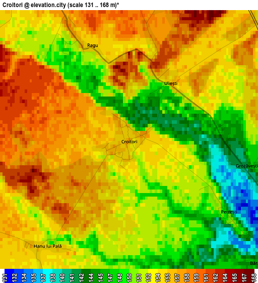
Below is the Elevation map of Croitori, which displays elevation range with different colors. Scale of the first map is from 131 to 168 m (430 to 551 ft) with average elevation of 152.9 meters (=502 ft) [note 1]
These maps also provides idea of topography and contour of this city, they are displayed at different zoom levels. More info about maps, scale and edge coordinates you can find below images.
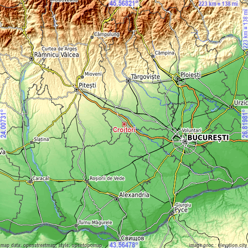
| \ | Map #1 | Topo.Map |
| Scale [m] | 131..168 m | × |
| Scale [ft] | 430..551 ft | × |
| Average | 152.9 m = 502 ft | × |
| Width | 6.96 km = 4.3 mi | 222.8 km = 138.4 mi |
| Height | 6.96 km = 4.3 mi | 222.7 km = 138.4 mi |
| ↑Max Latitude | 44.606415° | 45.56821° |
| Latitude at center | 44.57512° | 44.57512° |
| ↓Min Latitude | 44.543808° | 43.56478° |
| ← Min Longitude | 25.369615° | 24.00731° |
| Longitude center | 25.41356° | 25.41356° |
| →Max Longitude | 25.457505° | 26.81981° |
Nearby cities:
Cities around Croitori sort by population:
• Corbii Mari elevation 142 m
7.4 km,  112°
112°
• Vişina 165 m
6.4 km,  278°
278°
• Petreşti 174 m
10.5 km,  322°
322°
• Ulieşti 142 m
0.9 km,  15°
15°
• Costeştii din Vale 157 m
10 km,  33°
33°
• Răscăeți 177 m
11.5 km, 279°
• Ungureni 147 m
6.9 km,  87°
87°
• Grozăvești 142 m
3.2 km,  102°
102°
• Crovu 146 m
9.9 km,  80°
80°
• Greci 178 m
11.1 km,  329°
329°
• Zăvoiu 170 m
9.5 km,  355°
355°
• Zidurile 142 m
11.2 km, 86°
Multilingual:
 En español:
Croitori elevación 157 m.
 En France:
Croitori élévation 157 m.
 Auf Deutsch:
Croitori höhe über dem Meeresspiegel ist 157 m.

Sources and notes:
- [note 1] Map square and city borders are not equal. Map elevation data is calculated only from area inside that square.
- [src 1] Elevation data from geonames database provided with same terms of usage.
- [src 2] The elevation map of Croitori is generated using elevation data from NASA's 3 arcsec (90m) resolution SRTM data.
- [src 3] Base (background) map © OpenStreetMap contributors tiles are generated by Geofabrik and OpenTopoMap.
Copyright & License:
This Croitori Elevation Map is licensed under CC BY-SA. You may reuse any part from this page, if you give a proper credit by linking to this URL:
 More info on terms of use page.