Mbocayaty elevation
Mbocayaty (Guairá), Paraguay elevation is 143 meters and Mbocayaty elevation in feet is 469 ft above sea level [src 1]. Mbocayaty is a populated place (feature code) with elevation that is 31 meters (102 ft) smaller than average city elevation in Paraguay.
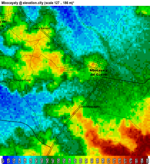
Below is the Elevation map of Mbocayaty, which displays elevation range with different colors. Scale of the first map is from 127 to 186 m (417 to 610 ft) with average elevation of 149 meters (=489 ft) [note 1]
These maps also provides idea of topography and contour of this city, they are displayed at different zoom levels. More info about maps, scale and edge coordinates you can find below images.
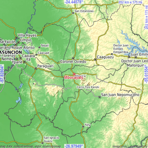
| \ | Map #1 | Topo.Map |
| Scale [m] | 127..186 m | × |
| Scale [ft] | 417..610 ft | × |
| Average | 149 m = 489 ft | × |
| Width | 8.8 km = 5.5 mi | 281.7 km = 175 mi |
| Height | 8.8 km = 5.5 mi | 281.7 km = 175 mi |
| ↑Max Latitude | -25.679782° | -24.44578° |
| Latitude at center | -25.71938° | -25.71938° |
| ↓Min Latitude | -25.758965° | -26.97949° |
| ← Min Longitude | -56.465735° | -57.82804° |
| Longitude center | -56.42179° | -56.42179° |
| →Max Longitude | -56.377845° | -55.01554° |
Nearby cities:
Cities around Mbocayaty sort by population:
• Caaguazú elevation 336 m
49.2 km,  55°
55°
• Coronel Oviedo 169 m
30.6 km,  356°
356°
• Villarrica 143 m
3.6 km,  201°
201°
• San José 125 m
37.5 km,  303°
303°
• Iturbe 113 m
37.9 km,  189°
189°
• La Colmena 174 m
45.9 km,  246°
246°
• Colonia Mauricio José Troche 146 m
21.9 km,  39°
39°
• Natalicio Talavera 135 m
15.5 km,  51°
51°
• Itapé 126 m
24.2 km,  232°
232°
• Independencia 172 m
15.7 km,  78°
78°
• Coronel Martínez 124 m
20 km,  257°
257°
• Santa Elena 119 m
50.7 km,  312°
312°
Multilingual:
 En español:
Mbocayaty elevación 143 m.
 En France:
Mbocayaty élévation 143 m.
 Auf Deutsch:
Mbocayaty höhe über dem Meeresspiegel ist 143 m.

Sources and notes:
- [note 1] Map square and city borders are not equal. Map elevation data is calculated only from area inside that square.
- [src 1] Elevation data from geonames database provided with same terms of usage.
- [src 2] The elevation map of Mbocayaty is generated using elevation data from NASA's 3 arcsec (90m) resolution SRTM data.
- [src 3] Base (background) map © OpenStreetMap contributors tiles are generated by Geofabrik and OpenTopoMap.
Copyright & License:
This Mbocayaty Elevation Map is licensed under CC BY-SA. You may reuse any part from this page, if you give a proper credit by linking to this URL:
 More info on terms of use page.