Iturbe elevation
Iturbe (Guairá), Paraguay elevation is 113 meters and Iturbe elevation in feet is 371 ft above sea level [src 1]. Iturbe is a populated place (feature code) with elevation that is 61 meters (200 ft) smaller than average city elevation in Paraguay.
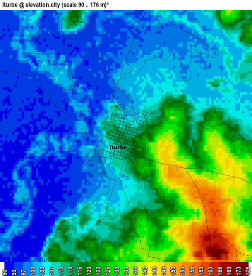
Below is the Elevation map of Iturbe, which displays elevation range with different colors. Scale of the first map is from 90 to 176 m (295 to 577 ft) with average elevation of 110 meters (=361 ft) [note 1]
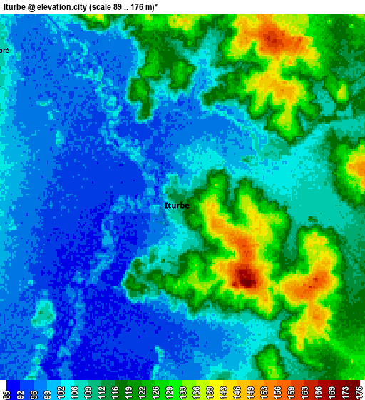
These maps also provides idea of topography and contour of this city, they are displayed at different zoom levels. More info about maps, scale and edge coordinates you can find below images.
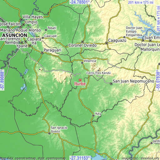
| \ | Map #1 | Map #2 | Topo.Map |
| Scale [m] | 90..176 m | 89..176 m | × |
| Scale [ft] | 295..577 ft | 292..577 ft | × |
| Average | 110 m = 361 ft | 110.1 m = 361 ft | × |
| Width | 8.78 km = 5.5 mi | 17.56 km = 10.9 mi | 280.9 km = 174.5 mi |
| Height | 8.78 km = 5.5 mi | 17.56 km = 10.9 mi | 280.9 km = 174.5 mi |
| ↑Max Latitude | -26.015594° | -25.976095° | -24.78501° |
| Latitude at center | -26.05508° | -26.05508° | -26.05508° |
| ↓Min Latitude | -26.094553° | -26.134012° | -27.31153° |
| ← Min Longitude | -56.528575° | -56.572521° | -57.89088° |
| Longitude center | -56.48463° | -56.48463° | -56.48463° |
| →Max Longitude | -56.440685° | -56.396739° | -55.07838° |
Nearby cities:
Cities around Iturbe sort by population:
• Villarrica elevation 143 m
34.3 km,  8°
8°
• Caazapá 150 m
19.5 km,  143°
143°
• San Juan Nepomuceno 145 m
54.9 km,  96°
96°
• La Colmena 174 m
40.3 km,  297°
297°
• Mbocayaty 143 m
37.9 km, 9°
• Mbuyapey 132 m
32.8 km,  236°
236°
• Natalicio Talavera 135 m
50.4 km,  21°
21°
• Itapé 126 m
26 km,  330°
330°
• Buena Vista 147 m
42.7 km,  109°
109°
• Independencia 172 m
45.9 km,  28°
28°
• Coronel Martínez 124 m
35.5 km,  338°
338°
• Yegros 115 m
44.7 km,  169°
169°
Multilingual:
 En español:
Iturbe elevación 113 m.
 En France:
Iturbe élévation 113 m.


Sources and notes:
- [note 1] Map square and city borders are not equal. Map elevation data is calculated only from area inside that square.
- [src 1] Elevation data from geonames database provided with same terms of usage.
- [src 2] The elevation map of Iturbe is generated using elevation data from NASA's 3 arcsec (90m) resolution SRTM data.
- [src 3] Base (background) map © OpenStreetMap contributors tiles are generated by Geofabrik and OpenTopoMap.
Copyright & License:
This Iturbe Elevation Map is licensed under CC BY-SA. You may reuse any part from this page, if you give a proper credit by linking to this URL:
 More info on terms of use page.