Santo Isidoro elevation
Santo Isidoro (Lisbon, Mafra), Portugal elevation is 73 meters and Santo Isidoro elevation in feet is 240 ft above sea level [src 1]. Santo Isidoro is a populated place (feature code) with elevation that is 95 meters (312 ft) smaller than average city elevation in Portugal.
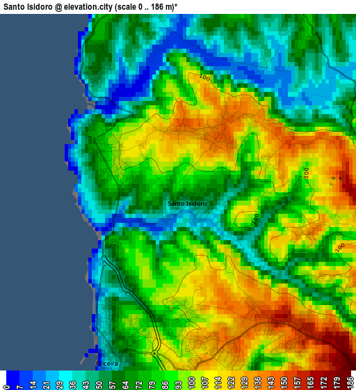
Below is the Elevation map of Santo Isidoro, which displays elevation range with different colors. Scale of the first map is from 0 to 186 m (0 to 610 ft) with average elevation of 81 meters (=266 ft) [note 1]
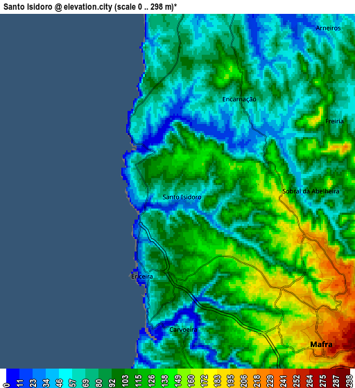
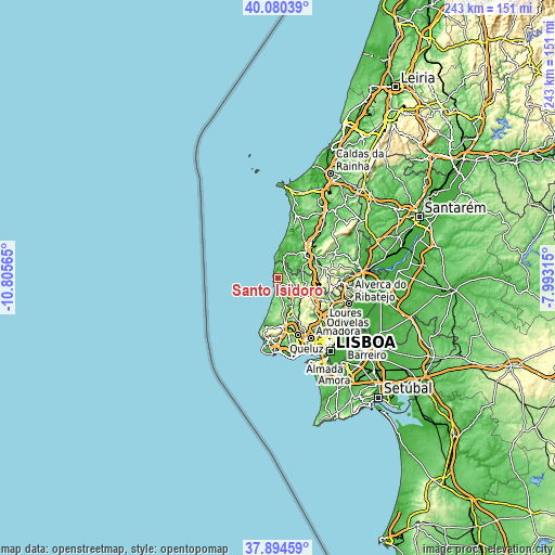
These maps also provides idea of topography and contour of this city, they are displayed at different zoom levels. More info about maps, scale and edge coordinates you can find below images.
| \ | Map #1 | Map #2 | Topo.Map |
| Scale [m] | 0..186 m | 0..298 m | × |
| Scale [ft] | 0..610 ft | 0..978 ft | × |
| Average | 81 m = 266 ft | 97.6 m = 320 ft | × |
| Width | 7.6 km = 4.7 mi | 15.19 km = 9.4 mi | 243 km = 151 mi |
| Height | 7.6 km = 4.7 mi | 15.19 km = 9.4 mi | 243 km = 151 mi |
| ↑Max Latitude | 39.030076° | 39.064205° | 40.08039° |
| Latitude at center | 38.99593° | 38.99593° | 38.99593° |
| ↓Min Latitude | 38.961768° | 38.927589° | 37.89459° |
| ← Min Longitude | -9.443345° | -9.487291° | -10.80565° |
| Longitude center | -9.3994° | -9.3994° | -9.3994° |
| →Max Longitude | -9.355455° | -9.311509° | -7.99315° |
Nearby cities:
Cities around Santo Isidoro sort by population:
• Torres Vedras elevation 41 m
16.1 km,  48°
48°
• Mafra 230 m
9 km,  136°
136°
• São João das Lampas 154 m
13.6 km,  179°
179°
• Ericeira 33 m
3.9 km,  200°
200°
• Silveira 37 m
13.2 km,  13°
13°
• A dos Cunhados 32 m
19.5 km,  26°
26°
• Fontanelas 129 m
16.8 km,  191°
191°
• Milharado 211 m
18.1 km,  107°
107°
• Venda do Pinheiro 263 m
16.6 km,  119°
119°
• Pero Pinheiro 158 m
16.7 km,  156°
156°
• Malveira 253 m
14.1 km, 120°
• São Pedro da Cadeira 61 m
8.6 km,  16°
16°
Multilingual:
 En español:
Santo Isidoro elevación 73 m.
 En France:
Santo Isidoro élévation 73 m.
 Auf Deutsch:
Santo Isidoro höhe über dem Meeresspiegel ist 73 m.

Sources and notes:
- [note 1] Map square and city borders are not equal. Map elevation data is calculated only from area inside that square.
- [src 1] Elevation data from geonames database provided with same terms of usage.
- [src 2] The elevation map of Santo Isidoro is generated using elevation data from NASA's 3 arcsec (90m) resolution SRTM data.
- [src 3] Base (background) map © OpenStreetMap contributors tiles are generated by Geofabrik and OpenTopoMap.
Copyright & License:
This Santo Isidoro Elevation Map is licensed under CC BY-SA. You may reuse any part from this page, if you give a proper credit by linking to this URL:
 More info on terms of use page.