Arazede elevation
Arazede (Coimbra, Montemor-O-Velho), Portugal elevation is 89 meters and Arazede elevation in feet is 292 ft above sea level [src 1]. Arazede is a populated place (feature code) with elevation that is 79 meters (259 ft) smaller than average city elevation in Portugal.
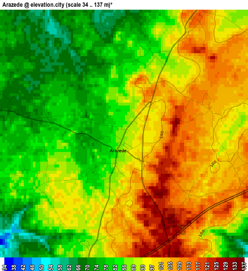
Below is the Elevation map of Arazede, which displays elevation range with different colors. Scale of the first map is from 34 to 137 m (112 to 449 ft) with average elevation of 90.6 meters (=297 ft) [note 1]
These maps also provides idea of topography and contour of this city, they are displayed at different zoom levels. More info about maps, scale and edge coordinates you can find below images.
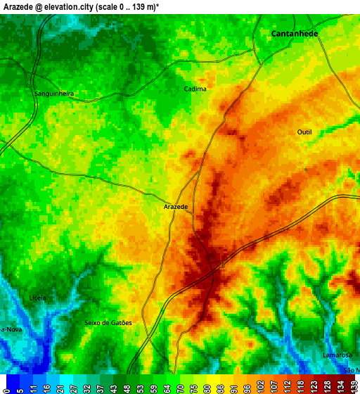
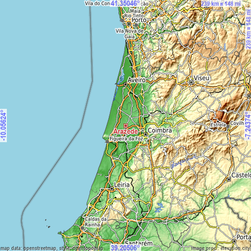
| \ | Map #1 | Map #2 | Topo.Map |
| Scale [m] | 34..137 m | 0..139 m | × |
| Scale [ft] | 112..449 ft | 0..456 ft | × |
| Average | 90.6 m = 297 ft | 73.3 m = 240 ft | × |
| Width | 7.45 km = 4.6 mi | 14.91 km = 9.3 mi | 238.5 km = 148.2 mi |
| Height | 7.45 km = 4.6 mi | 14.91 km = 9.3 mi | 238.5 km = 148.2 mi |
| ↑Max Latitude | 40.319784° | 40.353282° | 41.35046° |
| Latitude at center | 40.28627° | 40.28627° | 40.28627° |
| ↓Min Latitude | 40.252739° | 40.219192° | 39.20506° |
| ← Min Longitude | -8.693935° | -8.737881° | -10.05624° |
| Longitude center | -8.64999° | -8.64999° | -8.64999° |
| →Max Longitude | -8.606045° | -8.562099° | -7.24374° |
Nearby cities:
Cities around Arazede sort by population:
• Santa Clara elevation 14 m
20.2 km,  118°
118°
• Tavarede 41 m
21.3 km,  231°
231°
• Mira 32 m
17.5 km,  334°
334°
• Cantanhede 63 m
8.2 km,  35°
35°
• Pampilhosa do Botão 73 m
19.7 km,  73°
73°
• Mealhada 54 m
19.8 km,  58°
58°
• Tocha 66 m
9.3 km,  288°
288°
• Alhadas 76 m
16.3 km, 226°
• Montemor-o-Velho 20 m
13 km,  193°
193°
• Carapinheira 34 m
8.9 km,  178°
178°
• Ançã 48 m
11.1 km,  98°
98°
• Alfarelos 59 m
15.1 km, 181°
Multilingual:
 En español:
Arazede elevación 89 m.
 En France:
Arazede élévation 89 m.


Sources and notes:
- [note 1] Map square and city borders are not equal. Map elevation data is calculated only from area inside that square.
- [src 1] Elevation data from geonames database provided with same terms of usage.
- [src 2] The elevation map of Arazede is generated using elevation data from NASA's 3 arcsec (90m) resolution SRTM data.
- [src 3] Base (background) map © OpenStreetMap contributors tiles are generated by Geofabrik and OpenTopoMap.
Copyright & License:
This Arazede Elevation Map is licensed under CC BY-SA. You may reuse any part from this page, if you give a proper credit by linking to this URL:
 More info on terms of use page.