Pampilhosa do Botão elevation
Pampilhosa do Botão (Aveiro, Mealhada), Portugal elevation is 73 meters and Pampilhosa do Botão elevation in feet is 240 ft above sea level [src 1]. Pampilhosa do Botão is a populated place (feature code) with elevation that is 95 meters (312 ft) smaller than average city elevation in Portugal.
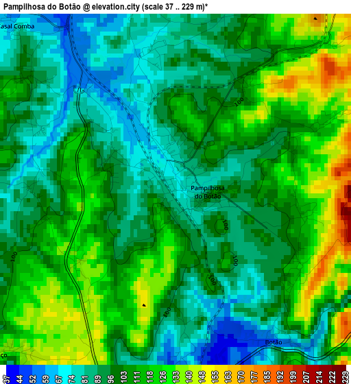
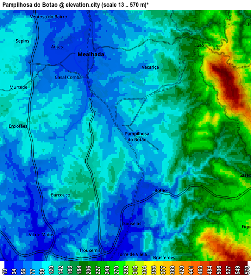
Below is the Elevation map of Pampilhosa do Botão, which displays elevation range with different colors. Scale of the first map is from 37 to 229 m (121 to 751 ft) with average elevation of 103 meters (=338 ft) [note 1]
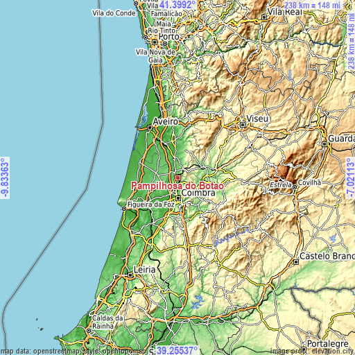
These maps also provides idea of topography and contour of this city, they are displayed at different zoom levels. More info about maps, scale and edge coordinates you can find below images.
| \ | Map #1 | Map #2 | Topo.Map |
| Scale [m] | 37..229 m | 13..570 m | × |
| Scale [ft] | 121..751 ft | 43..1870 ft | × |
| Average | 103 m = 338 ft | 135 m = 443 ft | × |
| Width | 7.45 km = 4.6 mi | 14.9 km = 9.3 mi | 238.4 km = 148.1 mi |
| Height | 7.45 km = 4.6 mi | 14.9 km = 9.3 mi | 238.4 km = 148.1 mi |
| ↑Max Latitude | 40.36929° | 40.402763° | 41.3992° |
| Latitude at center | 40.3358° | 40.3358° | 40.3358° |
| ↓Min Latitude | 40.302294° | 40.268771° | 39.25537° |
| ← Min Longitude | -8.471325° | -8.515271° | -9.83363° |
| Longitude center | -8.42738° | -8.42738° | -8.42738° |
| →Max Longitude | -8.383435° | -8.339489° | -7.02113° |
Nearby cities:
Cities around Pampilhosa do Botão sort by population:
• Coimbra elevation 98 m
14.5 km,  177°
177°
• Santo António dos Olivais 122 m
13.2 km,  171°
171°
• Santa Clara 14 m
15.2 km, 184°
• Cantanhede 63 m
14.2 km,  274°
274°
• Arcos 35 m
12.5 km,  354°
354°
• Sangalhos 86 m
17.2 km, 347°
• Mealhada 54 m
5.1 km,  337°
337°
• Lorvão 174 m
12.7 km,  132°
132°
• Penacova 143 m
14.4 km,  121°
121°
• Ançã 48 m
10.7 km,  228°
228°
• Luso 204 m
6.8 km,  37°
37°
• Anadia 49 m
11.4 km,  357°
357°
Multilingual:
 En español:
Pampilhosa do Botão elevación 73 m.
 En France:
Pampilhosa do Botão élévation 73 m.
 Auf Deutsch:
Pampilhosa do Botão höhe über dem Meeresspiegel ist 73 m.
 На русском:
Pampilhosa do Botão высота над уровнем моря 73 м
Sources and notes:
- [note 1] Map square and city borders are not equal. Map elevation data is calculated only from area inside that square.
- [src 1] Elevation data from geonames database provided with same terms of usage.
- [src 2] The elevation map of Pampilhosa do Botão is generated using elevation data from NASA's 3 arcsec (90m) resolution SRTM data.
- [src 3] Base (background) map © OpenStreetMap contributors tiles are generated by Geofabrik and OpenTopoMap.
Copyright & License:
This Pampilhosa do Botão Elevation Map is licensed under CC BY-SA. You may reuse any part from this page, if you give a proper credit by linking to this URL:
 More info on terms of use page.