Arcos elevation
Arcos (Aveiro, Anadia), Portugal elevation is 35 meters and Arcos elevation in feet is 115 ft above sea level [src 1]. Arcos is a populated place (feature code) with elevation that is 133 meters (436 ft) smaller than average city elevation in Portugal.
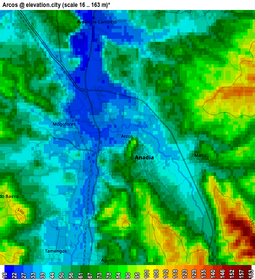
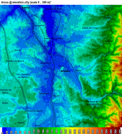
Below is the Elevation map of Arcos, which displays elevation range with different colors. Scale of the first map is from 16 to 163 m (52 to 535 ft) with average elevation of 60.6 meters (=199 ft) [note 1]
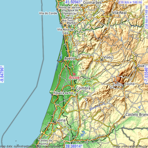
These maps also provides idea of topography and contour of this city, they are displayed at different zoom levels. More info about maps, scale and edge coordinates you can find below images.
| \ | Map #1 | Map #2 | Topo.Map |
| Scale [m] | 16..163 m | 9..399 m | × |
| Scale [ft] | 52..535 ft | 30..1309 ft | × |
| Average | 60.6 m = 199 ft | 91.3 m = 300 ft | × |
| Width | 7.44 km = 4.6 mi | 14.87 km = 9.2 mi | 238 km = 147.9 mi |
| Height | 7.44 km = 4.6 mi | 14.87 km = 9.2 mi | 238 km = 147.9 mi |
| ↑Max Latitude | 40.481224° | 40.514641° | 41.50941° |
| Latitude at center | 40.44779° | 40.44779° | 40.44779° |
| ↓Min Latitude | 40.414339° | 40.380872° | 39.36914° |
| ← Min Longitude | -8.485655° | -8.529601° | -9.84796° |
| Longitude center | -8.44171° | -8.44171° | -8.44171° |
| →Max Longitude | -8.397765° | -8.353819° | -7.03546° |
Nearby cities:
Cities around Arcos sort by population:
• Águeda elevation 39 m
14.4 km,  359°
359°
• Cantanhede 63 m
17.1 km,  228°
228°
• Oiã 63 m
13.4 km,  322°
322°
• Oliveira do Bairro 74 m
8.6 km,  329°
329°
• Valongo 73 m
18.8 km, 357°
• Sangalhos 86 m
4.9 km, 331°
• Pampilhosa do Botão 73 m
12.5 km,  174°
174°
• Mealhada 54 m
7.8 km,  185°
185°
• Aguada de Cima 41 m
8.4 km,  8°
8°
• Luso 204 m
8.9 km,  142°
142°
• Mortágua 100 m
18.6 km,  107°
107°
• Anadia 49 m
1.3 km,  146°
146°
Multilingual:
 En español:
Arcos elevación 35 m.
 En France:
Arcos élévation 35 m.


Sources and notes:
- [note 1] Map square and city borders are not equal. Map elevation data is calculated only from area inside that square.
- [src 1] Elevation data from geonames database provided with same terms of usage.
- [src 2] The elevation map of Arcos is generated using elevation data from NASA's 3 arcsec (90m) resolution SRTM data.
- [src 3] Base (background) map © OpenStreetMap contributors tiles are generated by Geofabrik and OpenTopoMap.
Copyright & License:
This Arcos Elevation Map is licensed under CC BY-SA. You may reuse any part from this page, if you give a proper credit by linking to this URL:
 More info on terms of use page.