Bragança elevation
Bragança, Portugal elevation is 673 meters and Bragança elevation in feet is 2208 ft above sea level [src 1]. Bragança is a seat of a first-order administrative division (feature code) with elevation that is 505 meters (1657 ft) bigger than average city elevation in Portugal.
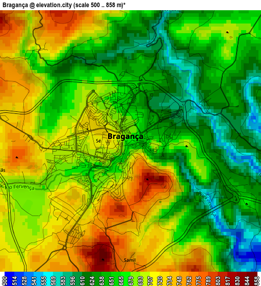
Below is the Elevation map of Bragança, which displays elevation range with different colors. Scale of the first map is from 500 to 858 m (1640 to 2815 ft) with average elevation of 678.6 meters (=2226 ft) [note 1]
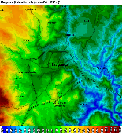
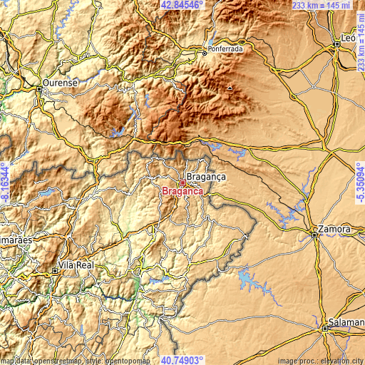
These maps also provides idea of topography and contour of this city, they are displayed at different zoom levels. More info about maps, scale and edge coordinates you can find below images.
| \ | Map #1 | Map #2 | Topo.Map |
| Scale [m] | 500..858 m | 464..1095 m | × |
| Scale [ft] | 1640..2815 ft | 1522..3593 ft | × |
| Average | 678.6 m = 2226 ft | 709 m = 2326 ft | × |
| Width | 7.28 km = 4.5 mi | 14.57 km = 9.1 mi | 233.1 km = 144.8 mi |
| Height | 7.28 km = 4.5 mi | 14.57 km = 9.1 mi | 233.1 km = 144.8 mi |
| ↑Max Latitude | 41.838569° | 41.871301° | 42.84546° |
| Latitude at center | 41.80582° | 41.80582° | 41.80582° |
| ↓Min Latitude | 41.773054° | 41.740272° | 40.74903° |
| ← Min Longitude | -6.801135° | -6.845081° | -8.16344° |
| Longitude center | -6.75719° | -6.75719° | -6.75719° |
| →Max Longitude | -6.713245° | -6.669299° | -5.35094° |
Nearby cities:
Cities around Bragança sort by population:
• Chaves elevation 362 m
59.5 km,  262°
262°
• Mirandela 215 m
50.3 km,  225°
225°
• Vinhais 706 m
20.8 km,  279°
279°
• Miranda do Douro 674 m
52.9 km,  130°
130°
• Macedo de Cavaleiros 558 m
34.2 km,  209°
209°
• Valpaços 432 m
51 km,  244°
244°
• Mogadouro 731 m
51.9 km,  175°
175°
• Santa Cruz 399 m
59.2 km,  265°
265°
• Sendim 718 m
54.1 km,  149°
149°
• Samil 750 m
3.3 km, 179°
• Alfândega da Fé 543 m
54.2 km,  198°
198°
• Vimioso 705 m
31.1 km,  142°
142°
Multilingual:
 En español:
Bragança elevación 673 m.
 En France:
Bragance élévation 673 m.
 Auf Deutsch:
Bragança höhe über dem Meeresspiegel ist 673 m.

Sources and notes:
- [note 1] Map square and city borders are not equal. Map elevation data is calculated only from area inside that square.
- [src 1] Elevation data from geonames database provided with same terms of usage.
- [src 2] The elevation map of Bragança is generated using elevation data from NASA's 3 arcsec (90m) resolution SRTM data.
- [src 3] Base (background) map © OpenStreetMap contributors tiles are generated by Geofabrik and OpenTopoMap.
Copyright & License:
This Bragança Elevation Map is licensed under CC BY-SA. You may reuse any part from this page, if you give a proper credit by linking to this URL:
 More info on terms of use page.