Mogadouro elevation
Mogadouro (Bragança), Portugal elevation is 731 meters and Mogadouro elevation in feet is 2398 ft above sea level [src 1]. Mogadouro is a populated place (feature code) with elevation that is 563 meters (1847 ft) bigger than average city elevation in Portugal.
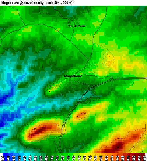
Below is the Elevation map of Mogadouro, which displays elevation range with different colors. Scale of the first map is from 594 to 906 m (1949 to 2972 ft) with average elevation of 722.7 meters (=2371 ft) [note 1]
These maps also provides idea of topography and contour of this city, they are displayed at different zoom levels. More info about maps, scale and edge coordinates you can find below images.
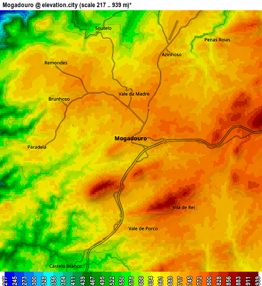
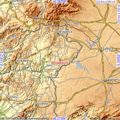
| \ | Map #1 | Map #2 | Topo.Map |
| Scale [m] | 594..906 m | 217..939 m | × |
| Scale [ft] | 1949..2972 ft | 712..3081 ft | × |
| Average | 722.7 m = 2371 ft | 680.4 m = 2232 ft | × |
| Width | 7.34 km = 4.6 mi | 14.67 km = 9.1 mi | 234.8 km = 145.9 mi |
| Height | 7.34 km = 4.6 mi | 14.67 km = 9.1 mi | 234.8 km = 145.9 mi |
| ↑Max Latitude | 41.373326° | 41.406295° | 42.38758° |
| Latitude at center | 41.34034° | 41.34034° | 41.34034° |
| ↓Min Latitude | 41.307338° | 41.274318° | 40.27598° |
| ← Min Longitude | -6.755815° | -6.799761° | -8.11812° |
| Longitude center | -6.71187° | -6.71187° | -6.71187° |
| →Max Longitude | -6.667925° | -6.623979° | -5.30562° |
Nearby cities:
Cities around Mogadouro sort by population:
• Mirandela elevation 215 m
42.9 km,  292°
292°
• Torre de Moncorvo 397 m
34 km,  237°
237°
• Miranda do Douro 674 m
40.5 km,  64°
64°
• Vila Nova de Foz Côa 385 m
46 km,  231°
231°
• Macedo de Cavaleiros 558 m
30.3 km,  316°
316°
• Freixo de Espada à Cinta 458 m
28.9 km,  195°
195°
• Sendim 718 m
24.4 km,  77°
77°
• Samil 750 m
48.6 km,  355°
355°
• Belver 762 m
48.3 km,  257°
257°
• Vila Flor 560 m
37.1 km, 264°
• Vimioso 705 m
31.2 km,  29°
29°
• Alfândega da Fé 543 m
20.8 km,  270°
270°
Multilingual:
 En español:
Mogadouro elevación 731 m.
 En France:
Mogadouro élévation 731 m.
 Auf Deutsch:
Mogadouro höhe über dem Meeresspiegel ist 731 m.

Sources and notes:
- [note 1] Map square and city borders are not equal. Map elevation data is calculated only from area inside that square.
- [src 1] Elevation data from geonames database provided with same terms of usage.
- [src 2] The elevation map of Mogadouro is generated using elevation data from NASA's 3 arcsec (90m) resolution SRTM data.
- [src 3] Base (background) map © OpenStreetMap contributors tiles are generated by Geofabrik and OpenTopoMap.
Copyright & License:
This Mogadouro Elevation Map is licensed under CC BY-SA. You may reuse any part from this page, if you give a proper credit by linking to this URL:
 More info on terms of use page.