Guarda elevation
Guarda, Portugal elevation is 1008 meters and Guarda elevation in feet is 3307 ft above sea level [src 1]. Guarda is a seat of a first-order administrative division (feature code) with elevation that is 840 meters (2756 ft) bigger than average city elevation in Portugal.
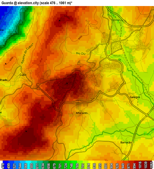
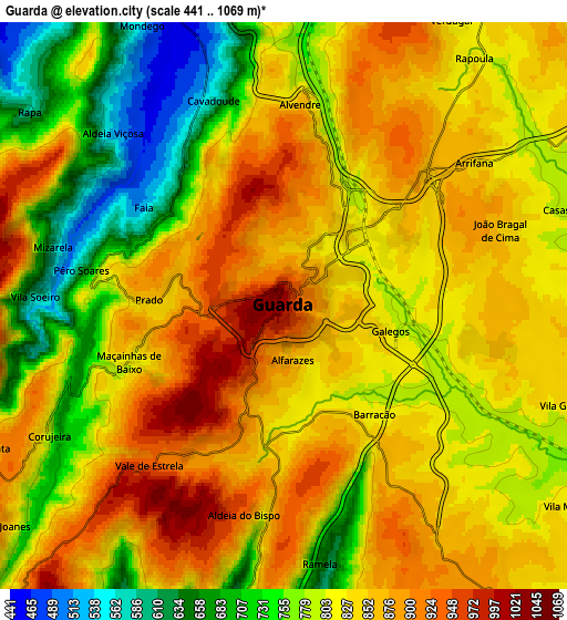
Below is the Elevation map of Guarda, which displays elevation range with different colors. Scale of the first map is from 476 to 1061 m (1562 to 3481 ft) with average elevation of 873.7 meters (=2866 ft) [note 1]
These maps also provides idea of topography and contour of this city, they are displayed at different zoom levels. More info about maps, scale and edge coordinates you can find below images.
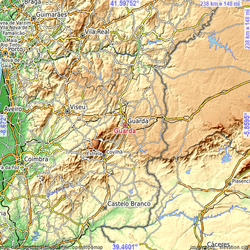
| \ | Map #1 | Map #2 | Topo.Map |
| Scale [m] | 476..1061 m | 441..1069 m | × |
| Scale [ft] | 1562..3481 ft | 1447..3507 ft | × |
| Average | 873.7 m = 2866 ft | 817.2 m = 2681 ft | × |
| Width | 7.43 km = 4.6 mi | 14.85 km = 9.2 mi | 237.7 km = 147.7 mi |
| Height | 7.43 km = 4.6 mi | 14.85 km = 9.2 mi | 237.7 km = 147.7 mi |
| ↑Max Latitude | 40.570719° | 40.604092° | 41.59752° |
| Latitude at center | 40.53733° | 40.53733° | 40.53733° |
| ↓Min Latitude | 40.503924° | 40.470501° | 39.4601° |
| ← Min Longitude | -7.309695° | -7.353641° | -8.672° |
| Longitude center | -7.26575° | -7.26575° | -7.26575° |
| →Max Longitude | -7.221805° | -7.177859° | -5.8595° |
Nearby cities:
Cities around Guarda sort by population:
• Sequeira elevation 853 m
3.8 km,  61°
61°
• Covilhã 534 m
35 km,  215°
215°
• Seia 551 m
39.8 km,  250°
250°
• Aguiar da Beira 794 m
39 km,  322°
322°
• Teixoso 561 m
29.6 km,  213°
213°
• Manteigas 794 m
27.6 km,  237°
237°
• Pinhel 645 m
31.2 km,  32°
32°
• Trancoso 860 m
28.3 km,  345°
345°
• Sabugal 753 m
25.4 km,  144°
144°
• Fornos de Algodres 677 m
25.3 km,  293°
293°
• Belmonte 606 m
21 km,  199°
199°
• Celorico da Beira 512 m
15.3 km, 316°
Multilingual:
 En español:
Guarda elevación 1008 m.
 En France:
Guarda élévation 1008 m.


Sources and notes:
- [note 1] Map square and city borders are not equal. Map elevation data is calculated only from area inside that square.
- [src 1] Elevation data from geonames database provided with same terms of usage.
- [src 2] The elevation map of Guarda is generated using elevation data from NASA's 3 arcsec (90m) resolution SRTM data.
- [src 3] Base (background) map © OpenStreetMap contributors tiles are generated by Geofabrik and OpenTopoMap.
Copyright & License:
This Guarda Elevation Map is licensed under CC BY-SA. You may reuse any part from this page, if you give a proper credit by linking to this URL:
 More info on terms of use page.