Seia elevation
Seia (Guarda), Portugal elevation is 551 meters and Seia elevation in feet is 1808 ft above sea level [src 1]. Seia is a seat of a second-order administrative division (feature code) with elevation that is 383 meters (1257 ft) bigger than average city elevation in Portugal.
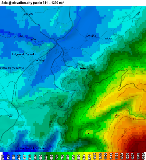
Below is the Elevation map of Seia, which displays elevation range with different colors. Scale of the first map is from 311 to 1390 m (1020 to 4560 ft) with average elevation of 606.8 meters (=1991 ft) [note 1]
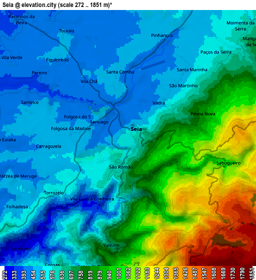
These maps also provides idea of topography and contour of this city, they are displayed at different zoom levels. More info about maps, scale and edge coordinates you can find below images.
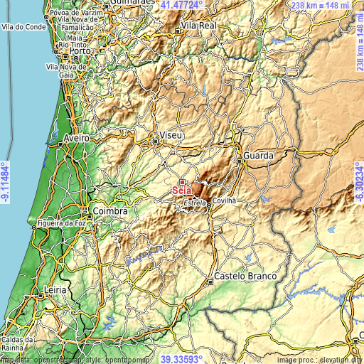
| \ | Map #1 | Map #2 | Topo.Map |
| Scale [m] | 311..1390 m | 272..1851 m | × |
| Scale [ft] | 1020..4560 ft | 892..6073 ft | × |
| Average | 606.8 m = 1991 ft | 699.9 m = 2296 ft | × |
| Width | 7.44 km = 4.6 mi | 14.88 km = 9.2 mi | 238.1 km = 147.9 mi |
| Height | 7.44 km = 4.6 mi | 14.88 km = 9.2 mi | 238.1 km = 147.9 mi |
| ↑Max Latitude | 40.44855° | 40.481984° | 41.47724° |
| Latitude at center | 40.4151° | 40.4151° | 40.4151° |
| ↓Min Latitude | 40.381633° | 40.34815° | 39.33593° |
| ← Min Longitude | -7.752535° | -7.796481° | -9.11484° |
| Longitude center | -7.70859° | -7.70859° | -7.70859° |
| →Max Longitude | -7.664645° | -7.620699° | -6.30234° |
Nearby cities:
Cities around Seia sort by population:
• Covilhã elevation 534 m
22.8 km,  130°
130°
• Mangualde 543 m
21.5 km,  348°
348°
• São Romão 594 m
1.6 km,  198°
198°
• Carregal do Sal 307 m
24.7 km,  274°
274°
• Oliveira do Hospital 508 m
14.1 km,  245°
245°
• Teixoso 561 m
24 km,  117°
117°
• Nelas 440 m
17.8 km,  317°
317°
• Manteigas 794 m
14.4 km,  95°
95°
• Canas de Senhorim 357 m
18.7 km,  300°
300°
• Cabanas de Viriato 294 m
23.5 km,  286°
286°
• Loriga 755 m
10.1 km,  170°
170°
• Fornos de Algodres 677 m
27.6 km,  30°
30°
Multilingual:
 En español:
Seia elevación 551 m.
 En France:
Seia élévation 551 m.


Sources and notes:
- [note 1] Map square and city borders are not equal. Map elevation data is calculated only from area inside that square.
- [src 1] Elevation data from geonames database provided with same terms of usage.
- [src 2] The elevation map of Seia is generated using elevation data from NASA's 3 arcsec (90m) resolution SRTM data.
- [src 3] Base (background) map © OpenStreetMap contributors tiles are generated by Geofabrik and OpenTopoMap.
Copyright & License:
This Seia Elevation Map is licensed under CC BY-SA. You may reuse any part from this page, if you give a proper credit by linking to this URL:
 More info on terms of use page.