Santo Tirso elevation
Santo Tirso (Porto), Portugal elevation is 81 meters and Santo Tirso elevation in feet is 266 ft above sea level [src 1]. Santo Tirso is a seat of a second-order administrative division (feature code) with elevation that is 87 meters (285 ft) smaller than average city elevation in Portugal.
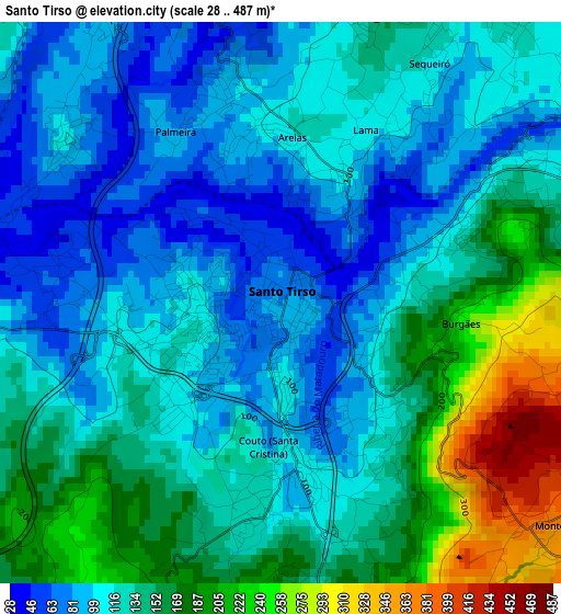
Below is the Elevation map of Santo Tirso, which displays elevation range with different colors. Scale of the first map is from 28 to 487 m (92 to 1598 ft) with average elevation of 132.7 meters (=435 ft) [note 1]
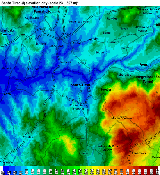
These maps also provides idea of topography and contour of this city, they are displayed at different zoom levels. More info about maps, scale and edge coordinates you can find below images.
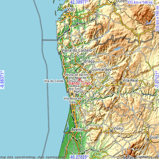
| \ | Map #1 | Map #2 | Topo.Map |
| Scale [m] | 28..487 m | 23..527 m | × |
| Scale [ft] | 92..1598 ft | 75..1729 ft | × |
| Average | 132.7 m = 435 ft | 169.1 m = 555 ft | × |
| Width | 7.34 km = 4.6 mi | 14.67 km = 9.1 mi | 234.8 km = 145.9 mi |
| Height | 7.34 km = 4.6 mi | 14.67 km = 9.1 mi | 234.8 km = 145.9 mi |
| ↑Max Latitude | 41.375555° | 41.408523° | 42.38977° |
| Latitude at center | 41.34257° | 41.34257° | 41.34257° |
| ↓Min Latitude | 41.309569° | 41.276551° | 40.27825° |
| ← Min Longitude | -8.521405° | -8.565351° | -9.88371° |
| Longitude center | -8.47746° | -8.47746° | -8.47746° |
| →Max Longitude | -8.433515° | -8.389569° | -7.07121° |
Nearby cities:
Cities around Santo Tirso sort by population:
• Bougado elevation 35 m
6.2 km,  267°
267°
• Trofa 44 m
6.9 km, 265°
• Calendário 103 m
8.1 km,  327°
327°
• Vila Nova de Famalicão 96 m
8.1 km, 334°
• Ribeirão 71 m
7.8 km,  285°
285°
• Aves 116 m
6.4 km,  61°
61°
• Ferreiros 39 m
6.1 km,  277°
277°
• Negrelos 164 m
6.4 km,  83°
83°
• São Miguel do Couto 119 m
1.8 km,  132°
132°
• Lordelo 150 m
8.8 km,  66°
66°
• Seroa 324 m
9.5 km,  154°
154°
• Rebordões 105 m
4.7 km, 72°
Multilingual:
 En español:
Santo Tirso elevación 81 m.
 En France:
Santo Tirso élévation 81 m.
 Auf Deutsch:
Santo Tirso höhe über dem Meeresspiegel ist 81 m.

Sources and notes:
- [note 1] Map square and city borders are not equal. Map elevation data is calculated only from area inside that square.
- [src 1] Elevation data from geonames database provided with same terms of usage.
- [src 2] The elevation map of Santo Tirso is generated using elevation data from NASA's 3 arcsec (90m) resolution SRTM data.
- [src 3] Base (background) map © OpenStreetMap contributors tiles are generated by Geofabrik and OpenTopoMap.
Copyright & License:
This Santo Tirso Elevation Map is licensed under CC BY-SA. You may reuse any part from this page, if you give a proper credit by linking to this URL:
 More info on terms of use page.