Seroa elevation
Seroa (Porto, Paços de Ferreira), Portugal elevation is 324 meters and Seroa elevation in feet is 1063 ft above sea level [src 1]. Seroa is a populated place (feature code) with elevation that is 156 meters (512 ft) bigger than average city elevation in Portugal.
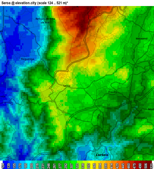
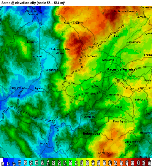
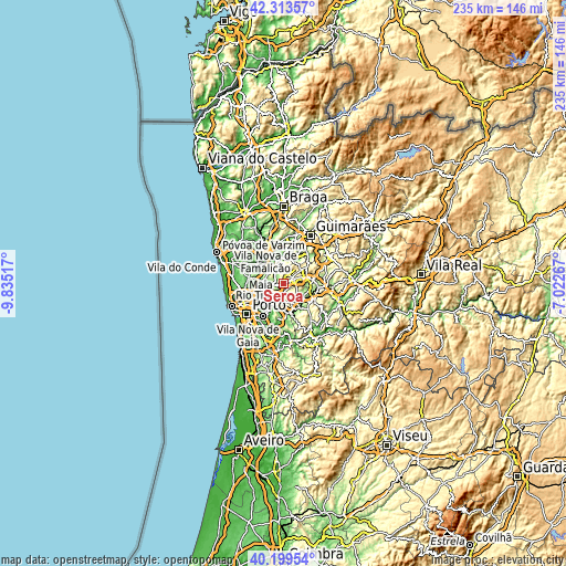
Below is the Elevation map of Seroa, which displays elevation range with different colors. Scale of the first map is from 124 to 521 m (407 to 1709 ft) with average elevation of 274.7 meters (=901 ft) [note 1]
These maps also provides idea of topography and contour of this city, they are displayed at different zoom levels. More info about maps, scale and edge coordinates you can find below images.
| \ | Map #1 | Map #2 | Topo.Map |
| Scale [m] | 124..521 m | 58..564 m | × |
| Scale [ft] | 407..1709 ft | 190..1850 ft | × |
| Average | 274.7 m = 901 ft | 268.7 m = 882 ft | × |
| Width | 7.35 km = 4.6 mi | 14.69 km = 9.1 mi | 235.1 km = 146.1 mi |
| Height | 7.35 km = 4.6 mi | 14.69 km = 9.1 mi | 235.1 km = 146.1 mi |
| ↑Max Latitude | 41.298134° | 41.331141° | 42.31357° |
| Latitude at center | 41.26511° | 41.26511° | 41.26511° |
| ↓Min Latitude | 41.232069° | 41.199012° | 40.19954° |
| ← Min Longitude | -8.472865° | -8.516811° | -9.83517° |
| Longitude center | -8.42892° | -8.42892° | -8.42892° |
| →Max Longitude | -8.384975° | -8.341029° | -7.02267° |
Nearby cities:
Cities around Seroa sort by population:
• Alfena elevation 117 m
8.6 km,  248°
248°
• Rebordosa 218 m
4.9 km,  157°
157°
• Lordelo 243 m
4 km,  147°
147°
• Freamunde 360 m
8.2 km,  71°
71°
• Paços de Ferreira 312 m
4.6 km, 73°
• Sobrado 121 m
6.5 km,  199°
199°
• Gandra 177 m
7.1 km,  183°
183°
• São Miguel do Couto 119 m
7.9 km,  339°
339°
• Carvalhosa 344 m
6.9 km,  55°
55°
• Frazão 258 m
2.5 km,  106°
106°
• Ferreira 336 m
7.1 km,  88°
88°
• Água Longa 116 m
5.6 km, 252°
Multilingual:
 En español:
Seroa elevación 324 m.
 En France:
Seroa élévation 324 m.


Sources and notes:
- [note 1] Map square and city borders are not equal. Map elevation data is calculated only from area inside that square.
- [src 1] Elevation data from geonames database provided with same terms of usage.
- [src 2] The elevation map of Seroa is generated using elevation data from NASA's 3 arcsec (90m) resolution SRTM data.
- [src 3] Base (background) map © OpenStreetMap contributors tiles are generated by Geofabrik and OpenTopoMap.
Copyright & License:
This Seroa Elevation Map is licensed under CC BY-SA. You may reuse any part from this page, if you give a proper credit by linking to this URL:
 More info on terms of use page.