Calendário elevation
Calendário (Braga, Vila Nova de Famalicão), Portugal elevation is 103 meters and Calendário elevation in feet is 338 ft above sea level [src 1]. Calendário is a populated place (feature code) with elevation that is 65 meters (213 ft) smaller than average city elevation in Portugal.
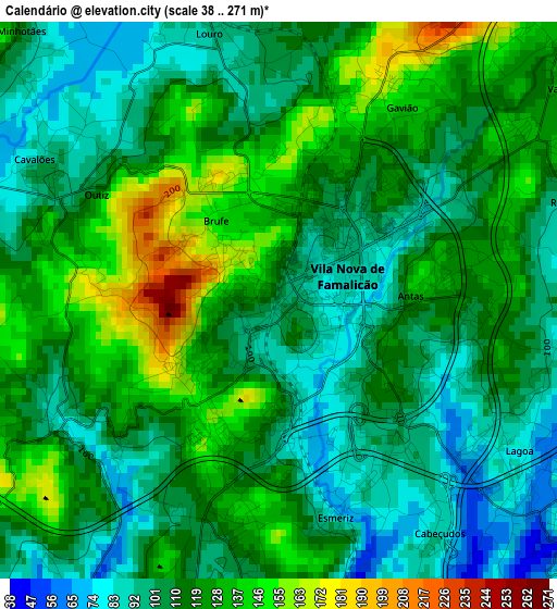
Below is the Elevation map of Calendário, which displays elevation range with different colors. Scale of the first map is from 38 to 271 m (125 to 889 ft) with average elevation of 114.4 meters (=375 ft) [note 1]
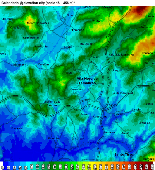
These maps also provides idea of topography and contour of this city, they are displayed at different zoom levels. More info about maps, scale and edge coordinates you can find below images.
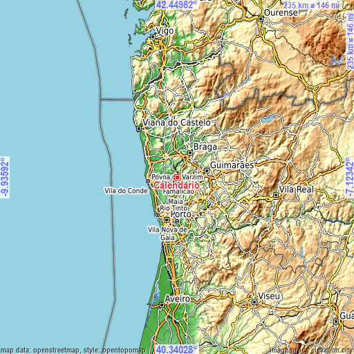
| \ | Map #1 | Map #2 | Topo.Map |
| Scale [m] | 38..271 m | 18..456 m | × |
| Scale [ft] | 125..889 ft | 59..1496 ft | × |
| Average | 114.4 m = 375 ft | 117 m = 384 ft | × |
| Width | 7.33 km = 4.6 mi | 14.66 km = 9.1 mi | 234.6 km = 145.8 mi |
| Height | 7.33 km = 4.6 mi | 14.66 km = 9.1 mi | 234.6 km = 145.8 mi |
| ↑Max Latitude | 41.436564° | 41.469501° | 42.44982° |
| Latitude at center | 41.40361° | 41.40361° | 41.40361° |
| ↓Min Latitude | 41.37064° | 41.337652° | 40.34028° |
| ← Min Longitude | -8.573615° | -8.617561° | -9.93592° |
| Longitude center | -8.52967° | -8.52967° | -8.52967° |
| →Max Longitude | -8.485725° | -8.441779° | -7.12342° |
Nearby cities:
Cities around Calendário sort by population:
• Bougado elevation 35 m
7.3 km,  194°
194°
• Trofa 44 m
7.8 km,  198°
198°
• Santo Tirso 81 m
8.1 km,  147°
147°
• Vila Nova de Famalicão 96 m
1 km,  59°
59°
• Ribeirão 71 m
5.7 km,  213°
213°
• Ferreiros 39 m
6.2 km, 195°
• Oliveira 184 m
9.7 km,  31°
31°
• Balazar 64 m
7.9 km,  270°
270°
• Chavão 174 m
8.1 km,  311°
311°
• Negreiros 118 m
7.9 km,  296°
296°
• Fradelos 52 m
7 km,  235°
235°
• Tebosa 173 m
9.6 km,  23°
23°
Multilingual:
 En español:
Calendário elevación 103 m.
 En France:
Calendário élévation 103 m.
 Auf Deutsch:
Calendário höhe über dem Meeresspiegel ist 103 m.

Sources and notes:
- [note 1] Map square and city borders are not equal. Map elevation data is calculated only from area inside that square.
- [src 1] Elevation data from geonames database provided with same terms of usage.
- [src 2] The elevation map of Calendário is generated using elevation data from NASA's 3 arcsec (90m) resolution SRTM data.
- [src 3] Base (background) map © OpenStreetMap contributors tiles are generated by Geofabrik and OpenTopoMap.
Copyright & License:
This Calendário Elevation Map is licensed under CC BY-SA. You may reuse any part from this page, if you give a proper credit by linking to this URL:
 More info on terms of use page.