Almodôvar elevation
Almodôvar (Beja), Portugal elevation is 290 meters and Almodôvar elevation in feet is 951 ft above sea level [src 1]. Almodôvar is a seat of a second-order administrative division (feature code) with elevation that is 122 meters (400 ft) bigger than average city elevation in Portugal.
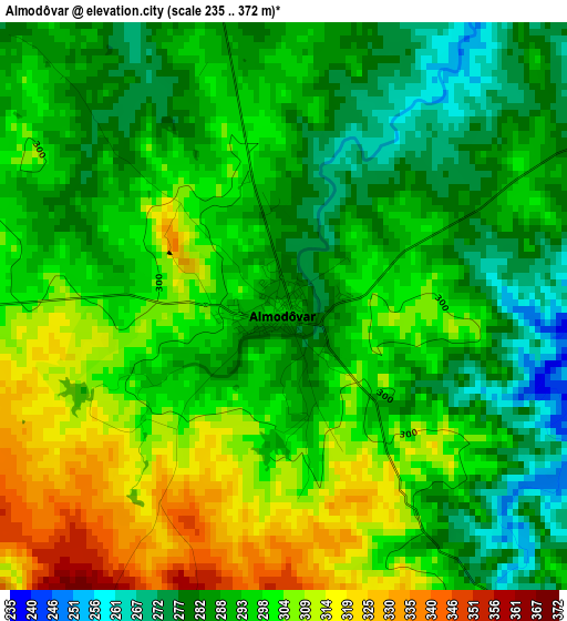
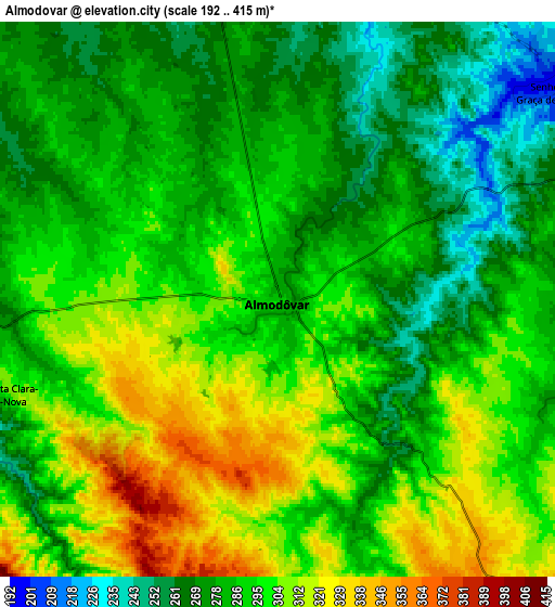
Below is the Elevation map of Almodôvar, which displays elevation range with different colors. Scale of the first map is from 235 to 372 m (771 to 1220 ft) with average elevation of 294.9 meters (=968 ft) [note 1]
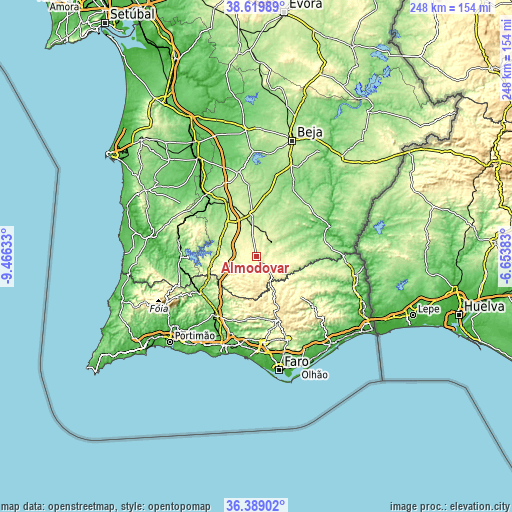
These maps also provides idea of topography and contour of this city, they are displayed at different zoom levels. More info about maps, scale and edge coordinates you can find below images.
| \ | Map #1 | Map #2 | Topo.Map |
| Scale [m] | 235..372 m | 192..415 m | × |
| Scale [ft] | 771..1220 ft | 630..1362 ft | × |
| Average | 294.9 m = 968 ft | 290.4 m = 953 ft | × |
| Width | 7.75 km = 4.8 mi | 15.5 km = 9.6 mi | 248 km = 154.1 mi |
| Height | 7.75 km = 4.8 mi | 15.5 km = 9.6 mi | 248 km = 154.1 mi |
| ↑Max Latitude | 37.54764° | 37.582474° | 38.61989° |
| Latitude at center | 37.51279° | 37.51279° | 37.51279° |
| ↓Min Latitude | 37.477924° | 37.443041° | 36.38902° |
| ← Min Longitude | -8.104025° | -8.147971° | -9.46633° |
| Longitude center | -8.06008° | -8.06008° | -8.06008° |
| →Max Longitude | -8.016135° | -7.972189° | -6.65383° |
Nearby cities:
Cities around Almodôvar sort by population:
• Loulé elevation 186 m
41.9 km,  175°
175°
• São Brás de Alportel 254 m
42.8 km,  159°
159°
• São Bartolomeu de Messines 130 m
34.8 km,  215°
215°
• Mértola 57 m
38 km,  67°
67°
• Aljustrel 182 m
41.6 km,  347°
347°
• Castro Verde 242 m
20.7 km, 353°
• Boliqueime 120 m
42.7 km,  191°
191°
• Paderne 57 m
39.1 km,  198°
198°
• Algoz 41 m
44.5 km,  208°
208°
• Tunes 64 m
42.4 km, 204°
• São Marcos da Serra 115 m
32.7 km,  238°
238°
• Ourique 241 m
21.4 km,  317°
317°
Multilingual:
 En español:
Almodôvar elevación 290 m.
 En France:
Almodôvar élévation 290 m.
 Auf Deutsch:
Almodôvar höhe über dem Meeresspiegel ist 290 m.

Sources and notes:
- [note 1] Map square and city borders are not equal. Map elevation data is calculated only from area inside that square.
- [src 1] Elevation data from geonames database provided with same terms of usage.
- [src 2] The elevation map of Almodôvar is generated using elevation data from NASA's 3 arcsec (90m) resolution SRTM data.
- [src 3] Base (background) map © OpenStreetMap contributors tiles are generated by Geofabrik and OpenTopoMap.
Copyright & License:
This Almodôvar Elevation Map is licensed under CC BY-SA. You may reuse any part from this page, if you give a proper credit by linking to this URL:
 More info on terms of use page.