Arraiolos elevation
Arraiolos (Évora), Portugal elevation is 341 meters and Arraiolos elevation in feet is 1119 ft above sea level [src 1]. Arraiolos is a seat of a second-order administrative division (feature code) with elevation that is 173 meters (568 ft) bigger than average city elevation in Portugal.
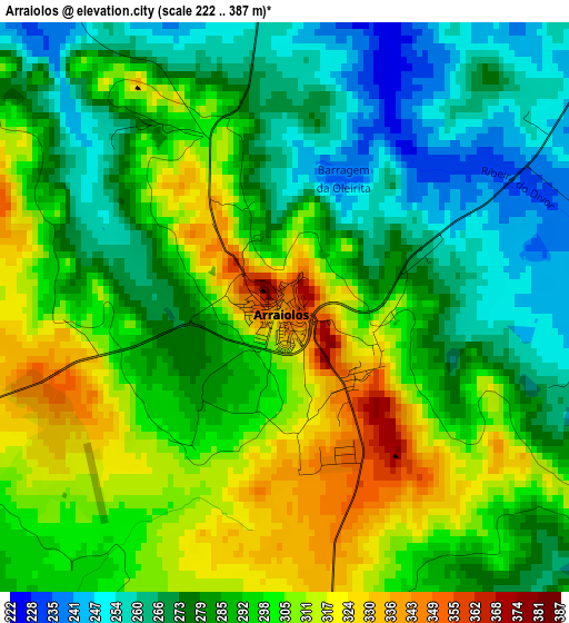
Below is the Elevation map of Arraiolos, which displays elevation range with different colors. Scale of the first map is from 222 to 387 m (728 to 1270 ft) with average elevation of 290.4 meters (=953 ft) [note 1]
These maps also provides idea of topography and contour of this city, they are displayed at different zoom levels. More info about maps, scale and edge coordinates you can find below images.
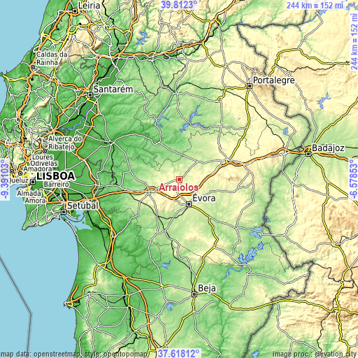
| \ | Map #1 | Topo.Map |
| Scale [m] | 222..387 m | × |
| Scale [ft] | 728..1270 ft | × |
| Average | 290.4 m = 953 ft | × |
| Width | 7.62 km = 4.7 mi | 244 km = 151.6 mi |
| Height | 7.62 km = 4.7 mi | 244 km = 151.6 mi |
| ↑Max Latitude | 38.757907° | 39.8123° |
| Latitude at center | 38.72363° | 38.72363° |
| ↓Min Latitude | 38.689337° | 37.61812° |
| ← Min Longitude | -8.028725° | -9.39103° |
| Longitude center | -7.98478° | -7.98478° |
| →Max Longitude | -7.940835° | -6.57853° |
Nearby cities:
Cities around Arraiolos sort by population:
• Évora elevation 269 m
18.9 km,  157°
157°
• Montemor-o-Novo 247 m
21.6 km,  247°
247°
• Vendas Novas 148 m
41.4 km,  262°
262°
• Santo André 94 m
43.2 km,  328°
328°
• Vale da Amoreira 207 m
45.8 km,  32°
32°
• Estremoz 417 m
37.1 km,  68°
68°
• Redondo 298 m
38.9 km,  102°
102°
• Borba 403 m
46.9 km,  78°
78°
• Montargil 155 m
42.5 km,  337°
337°
• Viana do Alentejo 249 m
43.3 km,  182°
182°
• Avis 176 m
37.6 km,  12°
12°
• Mora 113 m
29 km, 327°
Multilingual:
 En español:
Arraiolos elevación 341 m.
 En France:
Arraiolos élévation 341 m.
 Auf Deutsch:
Arraiolos höhe über dem Meeresspiegel ist 341 m.

Sources and notes:
- [note 1] Map square and city borders are not equal. Map elevation data is calculated only from area inside that square.
- [src 1] Elevation data from geonames database provided with same terms of usage.
- [src 2] The elevation map of Arraiolos is generated using elevation data from NASA's 3 arcsec (90m) resolution SRTM data.
- [src 3] Base (background) map © OpenStreetMap contributors tiles are generated by Geofabrik and OpenTopoMap.
Copyright & License:
This Arraiolos Elevation Map is licensed under CC BY-SA. You may reuse any part from this page, if you give a proper credit by linking to this URL:
 More info on terms of use page.