Santo André elevation
Santo André (Portalegre, Ponte de Sor), Portugal elevation is 94 meters and Santo André elevation in feet is 308 ft above sea level [src 1]. Santo André is a populated place (feature code) with elevation that is 74 meters (243 ft) smaller than average city elevation in Portugal.
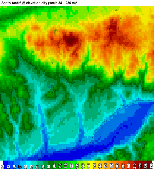
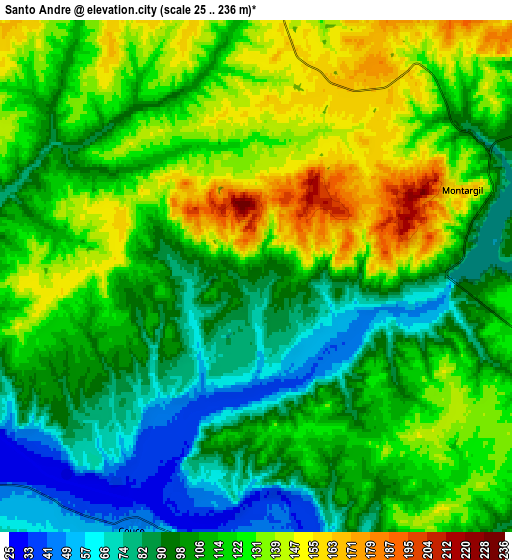
Below is the Elevation map of Santo André, which displays elevation range with different colors. Scale of the first map is from 34 to 236 m (112 to 774 ft) with average elevation of 113.1 meters (=371 ft) [note 1]
These maps also provides idea of topography and contour of this city, they are displayed at different zoom levels. More info about maps, scale and edge coordinates you can find below images.
| \ | Map #1 | Map #2 | Topo.Map |
| Scale [m] | 34..236 m | 25..236 m | × |
| Scale [ft] | 112..774 ft | 82..774 ft | × |
| Average | 113.1 m = 371 ft | 112.4 m = 369 ft | × |
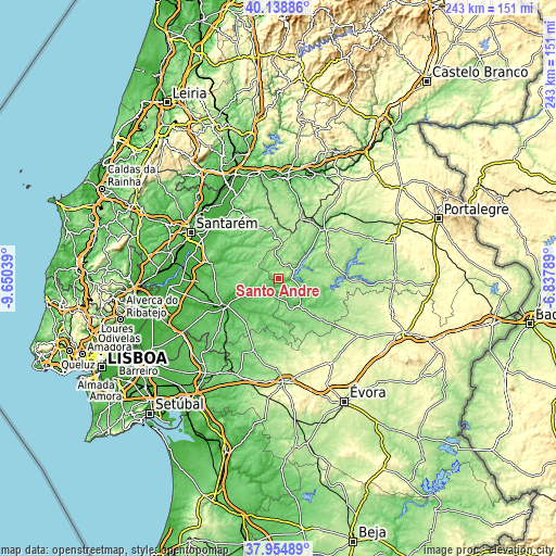
| Width | 7.59 km = 4.7 mi | 15.18 km = 9.4 mi | 242.8 km = 150.9 mi |
| Height | 7.59 km = 4.7 mi | 15.18 km = 9.4 mi | 242.8 km = 150.9 mi |
| ↑Max Latitude | 39.089437° | 39.123537° | 40.13886° |
| Latitude at center | 39.05532° | 39.05532° | 39.05532° |
| ↓Min Latitude | 39.021187° | 38.987037° | 37.95489° |
| ← Min Longitude | -8.288085° | -8.332031° | -9.65039° |
| Longitude center | -8.24414° | -8.24414° | -8.24414° |
| →Max Longitude | -8.200195° | -8.156249° | -6.83789° |
Nearby cities:
Cities around Santo André sort by population:
• Almeirim elevation 38 m
37.1 km,  297°
297°
• Ponte de Sôr 108 m
29.6 km,  43°
43°
• Coruche 21 m
26.5 km,  246°
246°
• Alpiarça 24 m
36.8 km,  307°
307°
• Fazendas de Almeirim 77 m
31.1 km, 295°
• Marinhais 34 m
39.6 km,  268°
268°
• Bemfica 11 m
39.5 km,  284°
284°
• Montargil 155 m
6.8 km,  68°
68°
• Azinhaga 19 m
40.9 km,  322°
322°
• Pinheiro Grande 46 m
40.9 km,  336°
336°
• Avis 176 m
30.4 km,  90°
90°
• Mora 113 m
14.2 km,  150°
150°
Multilingual:
 En español:
Santo André elevación 94 m.
 En France:
Santo André élévation 94 m.
 Auf Deutsch:
Santo André höhe über dem Meeresspiegel ist 94 m.

Sources and notes:
- [note 1] Map square and city borders are not equal. Map elevation data is calculated only from area inside that square.
- [src 1] Elevation data from geonames database provided with same terms of usage.
- [src 2] The elevation map of Santo André is generated using elevation data from NASA's 3 arcsec (90m) resolution SRTM data.
- [src 3] Base (background) map © OpenStreetMap contributors tiles are generated by Geofabrik and OpenTopoMap.
Copyright & License:
This Santo André Elevation Map is licensed under CC BY-SA. You may reuse any part from this page, if you give a proper credit by linking to this URL:
 More info on terms of use page.