Cercal elevation
Cercal (District of Setúbal, Santiago do Cacém), Portugal elevation is 138 meters and Cercal elevation in feet is 453 ft above sea level [src 1]. Cercal is a populated place (feature code) with elevation that is 30 meters (98 ft) smaller than average city elevation in Portugal.
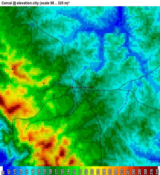
Below is the Elevation map of Cercal, which displays elevation range with different colors. Scale of the first map is from 98 to 325 m (322 to 1066 ft) with average elevation of 170.2 meters (=558 ft) [note 1]
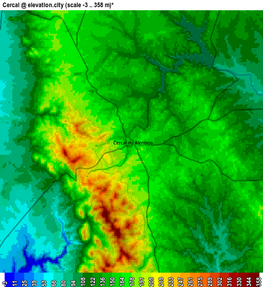
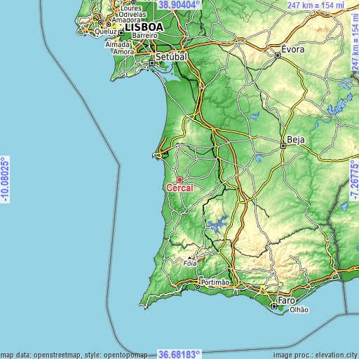
These maps also provides idea of topography and contour of this city, they are displayed at different zoom levels. More info about maps, scale and edge coordinates you can find below images.
| \ | Map #1 | Map #2 | Topo.Map |
| Scale [m] | 98..325 m | -3..358 m | × |
| Scale [ft] | 322..1066 ft | -10..1175 ft | × |
| Average | 170.2 m = 558 ft | 139.7 m = 458 ft | × |
| Width | 7.72 km = 4.8 mi | 15.44 km = 9.6 mi | 247.1 km = 153.5 mi |
| Height | 7.72 km = 4.8 mi | 15.44 km = 9.6 mi | 247.1 km = 153.5 mi |
| ↑Max Latitude | 37.836005° | 37.870703° | 38.90404° |
| Latitude at center | 37.80129° | 37.80129° | 37.80129° |
| ↓Min Latitude | 37.766559° | 37.731811° | 36.68183° |
| ← Min Longitude | -8.717945° | -8.761891° | -10.08025° |
| Longitude center | -8.674° | -8.674° | -8.674° |
| →Max Longitude | -8.630055° | -8.586109° | -7.26775° |
Nearby cities:
Cities around Cercal sort by population:
• Sines elevation 40 m
24.3 km,  315°
315°
• Santo André 32 m
30.4 km,  341°
341°
• Santiago do Cacém 220 m
24 km,  355°
355°
• Odemira 52 m
22.8 km,  172°
172°
• São Teotónio 153 m
32.2 km,  185°
185°
• Vila Nova de Milfontes 22 m
12.9 km,  227°
227°
• Zambujeira do Mar 45 m
31.9 km,  197°
197°
• Boavista dos Pinheiros 122 m
24.6 km,  178°
178°
• Porto Covo 31 m
11.7 km,  299°
299°
• Almograve 24 m
19.1 km,  212°
212°
• São Luis 158 m
9.6 km, 175°
• Ourique 241 m
42.7 km,  112°
112°
Multilingual:
 En español:
Cercal elevación 138 m.
 En France:
Cercal élévation 138 m.


Sources and notes:
- [note 1] Map square and city borders are not equal. Map elevation data is calculated only from area inside that square.
- [src 1] Elevation data from geonames database provided with same terms of usage.
- [src 2] The elevation map of Cercal is generated using elevation data from NASA's 3 arcsec (90m) resolution SRTM data.
- [src 3] Base (background) map © OpenStreetMap contributors tiles are generated by Geofabrik and OpenTopoMap.
Copyright & License:
This Cercal Elevation Map is licensed under CC BY-SA. You may reuse any part from this page, if you give a proper credit by linking to this URL:
 More info on terms of use page.