São Teotónio elevation
São Teotónio (Beja, Odemira), Portugal elevation is 153 meters and São Teotónio elevation in feet is 502 ft above sea level [src 1]. São Teotónio is a populated place (feature code) with elevation that is 15 meters (49 ft) smaller than average city elevation in Portugal.
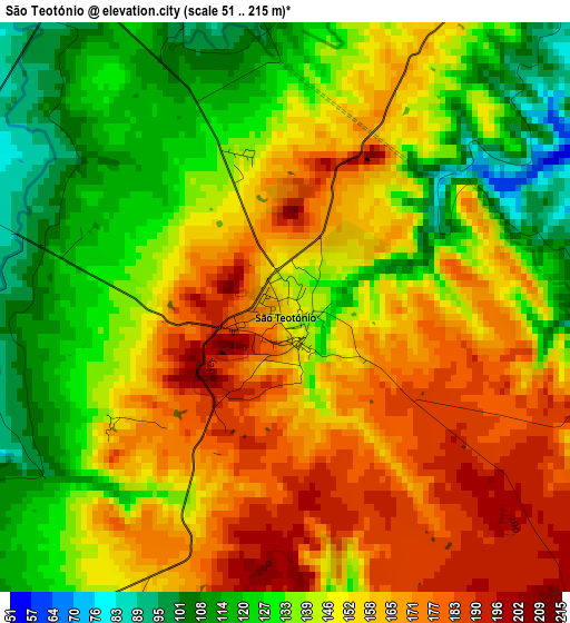
Below is the Elevation map of São Teotónio, which displays elevation range with different colors. Scale of the first map is from 51 to 215 m (167 to 705 ft) with average elevation of 147 meters (=482 ft) [note 1]
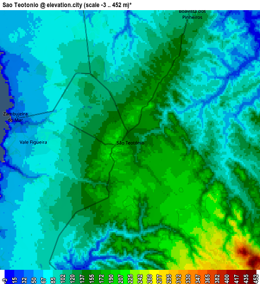
These maps also provides idea of topography and contour of this city, they are displayed at different zoom levels. More info about maps, scale and edge coordinates you can find below images.
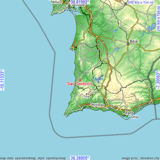
| \ | Map #1 | Map #2 | Topo.Map |
| Scale [m] | 51..215 m | -3..452 m | × |
| Scale [ft] | 167..705 ft | -10..1483 ft | × |
| Average | 147 m = 482 ft | 116.9 m = 384 ft | × |
| Width | 7.75 km = 4.8 mi | 15.5 km = 9.6 mi | 248 km = 154.1 mi |
| Height | 7.75 km = 4.8 mi | 15.5 km = 9.6 mi | 248 km = 154.1 mi |
| ↑Max Latitude | 37.54767° | 37.582504° | 38.61992° |
| Latitude at center | 37.51282° | 37.51282° | 37.51282° |
| ↓Min Latitude | 37.477954° | 37.443071° | 36.38905° |
| ← Min Longitude | -8.751025° | -8.794971° | -10.11333° |
| Longitude center | -8.70708° | -8.70708° | -8.70708° |
| →Max Longitude | -8.663135° | -8.619189° | -7.30083° |
Nearby cities:
Cities around São Teotónio sort by population:
• Aljezur elevation 101 m
23.3 km,  200°
200°
• Odemira 52 m
11.2 km,  32°
32°
• Monchique 439 m
25.5 km,  148°
148°
• Vila Nova de Milfontes 22 m
24.4 km,  344°
344°
• Cercal 138 m
32.2 km,  5°
5°
• Zambujeira do Mar 45 m
7.1 km,  283°
283°
• Boavista dos Pinheiros 122 m
8.4 km, 26°
• Porto Covo 31 m
38.5 km,  349°
349°
• Almograve 24 m
17.7 km,  334°
334°
• São Marcos da Serra 115 m
33.6 km,  120°
120°
• Marmelete 366 m
22.8 km,  171°
171°
• São Luis 158 m
22.8 km, 9°
Multilingual:
 En español:
São Teotónio elevación 153 m.
 En France:
São Teotónio élévation 153 m.
 Auf Deutsch:
São Teotónio höhe über dem Meeresspiegel ist 153 m.

Sources and notes:
- [note 1] Map square and city borders are not equal. Map elevation data is calculated only from area inside that square.
- [src 1] Elevation data from geonames database provided with same terms of usage.
- [src 2] The elevation map of São Teotónio is generated using elevation data from NASA's 3 arcsec (90m) resolution SRTM data.
- [src 3] Base (background) map © OpenStreetMap contributors tiles are generated by Geofabrik and OpenTopoMap.
Copyright & License:
This São Teotónio Elevation Map is licensed under CC BY-SA. You may reuse any part from this page, if you give a proper credit by linking to this URL:
 More info on terms of use page.