Monchique elevation
Monchique (Faro), Portugal elevation is 439 meters and Monchique elevation in feet is 1440 ft above sea level [src 1]. Monchique is a seat of a second-order administrative division (feature code) with elevation that is 271 meters (889 ft) bigger than average city elevation in Portugal.
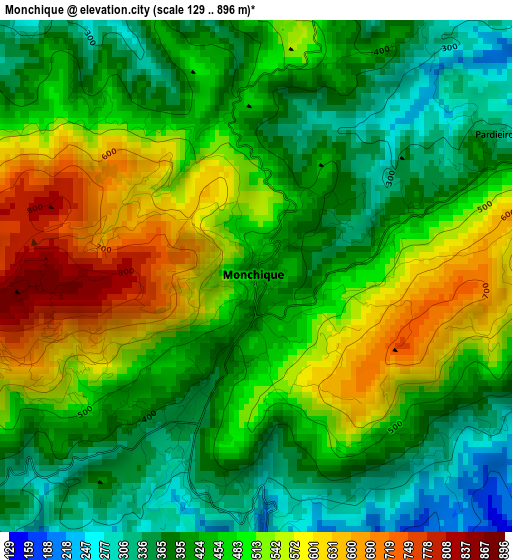
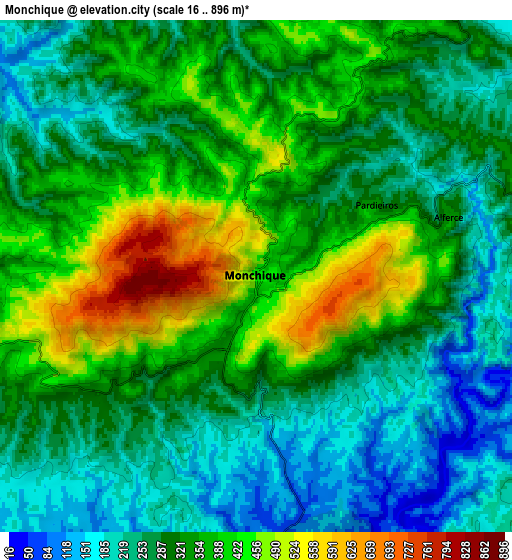
Below is the Elevation map of Monchique, which displays elevation range with different colors. Scale of the first map is from 129 to 896 m (423 to 2940 ft) with average elevation of 463.4 meters (=1520 ft) [note 1]
These maps also provides idea of topography and contour of this city, they are displayed at different zoom levels. More info about maps, scale and edge coordinates you can find below images.
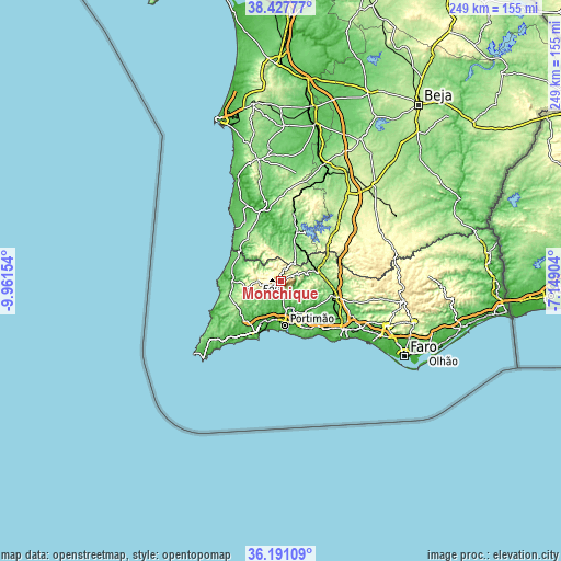
| \ | Map #1 | Map #2 | Topo.Map |
| Scale [m] | 129..896 m | 16..896 m | × |
| Scale [ft] | 423..2940 ft | 52..2940 ft | × |
| Average | 463.4 m = 1520 ft | 318.6 m = 1045 ft | × |
| Width | 7.77 km = 4.8 mi | 15.54 km = 9.7 mi | 248.7 km = 154.5 mi |
| Height | 7.77 km = 4.8 mi | 15.54 km = 9.7 mi | 248.7 km = 154.5 mi |
| ↑Max Latitude | 37.352691° | 37.387616° | 38.42777° |
| Latitude at center | 37.31775° | 37.31775° | 37.31775° |
| ↓Min Latitude | 37.282793° | 37.247819° | 36.19109° |
| ← Min Longitude | -8.599235° | -8.643181° | -9.96154° |
| Longitude center | -8.55529° | -8.55529° | -8.55529° |
| →Max Longitude | -8.511345° | -8.467399° | -7.14904° |
Nearby cities:
Cities around Monchique sort by population:
• Portimão elevation 13 m
20 km,  175°
175°
• Silves 27 m
17.7 km,  144°
144°
• Estômbar 29 m
20.1 km,  161°
161°
• Lagoa 53 m
22.2 km, 155°
• Aljezur 101 m
21.8 km,  269°
269°
• Alvor 16 m
21.1 km,  188°
188°
• Mexilhoeira Grande 40 m
18.5 km,  196°
196°
• Parchal 9 m
20.2 km,  170°
170°
• Bensafrim 33 m
24 km,  221°
221°
• Ferragudo 5 m
21.7 km, 171°
• São Marcos da Serra 115 m
16.4 km,  72°
72°
• Marmelete 366 m
10 km, 265°
Multilingual:
 En español:
Monchique elevación 439 m.
 En France:
Monchique élévation 439 m.
 Auf Deutsch:
Monchique höhe über dem Meeresspiegel ist 439 m.

Sources and notes:
- [note 1] Map square and city borders are not equal. Map elevation data is calculated only from area inside that square.
- [src 1] Elevation data from geonames database provided with same terms of usage.
- [src 2] The elevation map of Monchique is generated using elevation data from NASA's 3 arcsec (90m) resolution SRTM data.
- [src 3] Base (background) map © OpenStreetMap contributors tiles are generated by Geofabrik and OpenTopoMap.
Copyright & License:
This Monchique Elevation Map is licensed under CC BY-SA. You may reuse any part from this page, if you give a proper credit by linking to this URL:
 More info on terms of use page.