An Nuway‘imah elevation
An Nuway‘imah (West Bank, Jericho), Palestinian Territory elevation is -127 meters and An Nuway‘imah elevation in feet is -417 ft above sea level [src 1]. An Nuway‘imah is a populated place (feature code) with elevation that is 594 meters (1949 ft) smaller than average city elevation in Palestinian Territory.
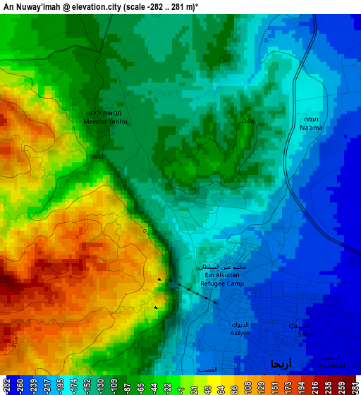
Below is the Elevation map of An Nuway‘imah, which displays elevation range with different colors. Scale of the first map is from -282 to 281 m (-925 to 922 ft) with average elevation of -97.5 meters (=-320 ft) [note 1]
These maps also provides idea of topography and contour of this city, they are displayed at different zoom levels. More info about maps, scale and edge coordinates you can find below images.
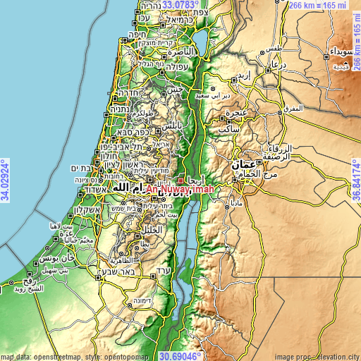
| \ | Map #1 | Topo.Map |
| Scale [m] | -282..281 m | × |
| Scale [ft] | -925..922 ft | × |
| Average | -97.5 m = -320 ft | × |
| Width | 8.3 km = 5.2 mi | 265.5 km = 165 mi |
| Height | 8.3 km = 5.2 mi | 265.5 km = 165 mi |
| ↑Max Latitude | 31.929424° | 33.0783° |
| Latitude at center | 31.89212° | 31.89212° |
| ↓Min Latitude | 31.854801° | 30.69046° |
| ← Min Longitude | 35.391545° | 34.02924° |
| Longitude center | 35.43549° | 35.43549° |
| →Max Longitude | 35.479435° | 36.84174° |
Nearby cities:
Cities around An Nuway‘imah sort by population:
• Jericho elevation -233 m
3.1 km,  154°
154°
• Dayr Dibwān 772 m
16.1 km,  277°
277°
• Dayr Jarīr 895 m
15.8 km,  301°
301°
• Al ‘Awjā -241 m
7.2 km,  24°
24°
• Jaba‘ 664 m
17.1 km,  256°
256°
• Rammūn 760 m
13.7 km,  289°
289°
• Kafr Mālik 790 m
16 km,  311°
311°
• Al Mughayyir 673 m
16.4 km,  329°
329°
• Burqah 748 m
17.1 km,  271°
271°
• Mikhmās 575 m
15.2 km, 261°
• Aţ Ţaybah 860 m
14.5 km, 298°
• Al Faşāyil -251 m
14.8 km,  2°
2°
Multilingual:
 En español:
An Nuway‘imah elevación -127 m.
 En France:
An Nuway‘imah élévation -127 m.
 Auf Deutsch:
An Nuway‘imah höhe über dem Meeresspiegel ist -127 m.

Sources and notes:
- [note 1] Map square and city borders are not equal. Map elevation data is calculated only from area inside that square.
- [src 1] Elevation data from geonames database provided with same terms of usage.
- [src 2] The elevation map of An Nuway‘imah is generated using elevation data from NASA's 3 arcsec (90m) resolution SRTM data.
- [src 3] Base (background) map © OpenStreetMap contributors tiles are generated by Geofabrik and OpenTopoMap.
Copyright & License:
This An Nuway‘imah Elevation Map is licensed under CC BY-SA. You may reuse any part from this page, if you give a proper credit by linking to this URL:
 More info on terms of use page.