As Sāwiyah elevation
As Sāwiyah (West Bank), Palestinian Territory elevation is 643 meters and As Sāwiyah elevation in feet is 2110 ft above sea level [src 1]. As Sāwiyah is a populated place (feature code) with elevation that is 176 meters (577 ft) bigger than average city elevation in Palestinian Territory.
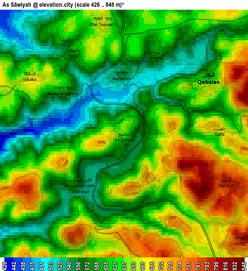
Below is the Elevation map of As Sāwiyah, which displays elevation range with different colors. Scale of the first map is from 426 to 848 m (1398 to 2782 ft) with average elevation of 620.7 meters (=2036 ft) [note 1]
These maps also provides idea of topography and contour of this city, they are displayed at different zoom levels. More info about maps, scale and edge coordinates you can find below images.
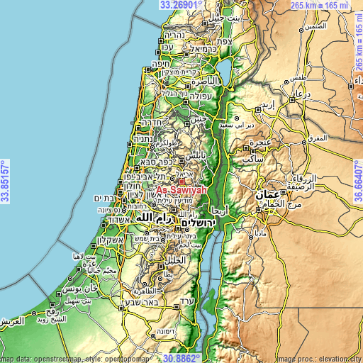
| \ | Map #1 | Topo.Map |
| Scale [m] | 426..848 m | × |
| Scale [ft] | 1398..2782 ft | × |
| Average | 620.7 m = 2036 ft | × |
| Width | 8.28 km = 5.1 mi | 264.9 km = 164.6 mi |
| Height | 8.28 km = 5.1 mi | 264.9 km = 164.6 mi |
| ↑Max Latitude | 32.122595° | 33.26901° |
| Latitude at center | 32.08537° | 32.08537° |
| ↓Min Latitude | 32.048129° | 30.8862° |
| ← Min Longitude | 35.213875° | 33.85157° |
| Longitude center | 35.25782° | 35.25782° |
| →Max Longitude | 35.301765° | 36.66407° |
Nearby cities:
Cities around As Sāwiyah sort by population:
• Qabalān elevation 620 m
3.5 km,  58°
58°
• Sinjil 801 m
5.8 km,  172°
172°
• Quşrah 753 m
6.8 km,  89°
89°
• Turmus‘ayyā 683 m
6.1 km,  154°
154°
• Talfīt 693 m
3.1 km, 87°
• Yatmā 594 m
2.8 km,  22°
22°
• Al Lubban ash Sharqīyah 586 m
2.4 km,  224°
224°
• Qaryūt 791 m
3.8 km,  116°
116°
• Mardā 442 m
6.7 km,  298°
298°
• Yāsūf 580 m
3.2 km,  323°
323°
• Usarin 702 m
6.6 km,  48°
48°
• Jūrīsh 807 m
6.3 km,  73°
73°
Multilingual:
 En español:
As Sāwiyah elevación 643 m.
 En France:
As Sāwiyah élévation 643 m.
 Auf Deutsch:
As Sāwiyah höhe über dem Meeresspiegel ist 643 m.

Sources and notes:
- [note 1] Map square and city borders are not equal. Map elevation data is calculated only from area inside that square.
- [src 1] Elevation data from geonames database provided with same terms of usage.
- [src 2] The elevation map of As Sāwiyah is generated using elevation data from NASA's 3 arcsec (90m) resolution SRTM data.
- [src 3] Base (background) map © OpenStreetMap contributors tiles are generated by Geofabrik and OpenTopoMap.
Copyright & License:
This As Sāwiyah Elevation Map is licensed under CC BY-SA. You may reuse any part from this page, if you give a proper credit by linking to this URL:
 More info on terms of use page.