Bāqah ash Sharqīyah elevation
Bāqah ash Sharqīyah (West Bank), Palestinian Territory elevation is 104 meters and Bāqah ash Sharqīyah elevation in feet is 341 ft above sea level [src 1]. Bāqah ash Sharqīyah is a populated place (feature code) with elevation that is 363 meters (1191 ft) smaller than average city elevation in Palestinian Territory.
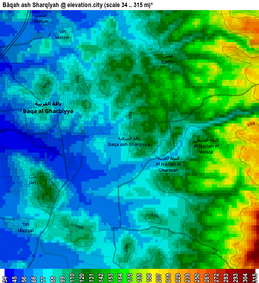
Below is the Elevation map of Bāqah ash Sharqīyah, which displays elevation range with different colors. Scale of the first map is from 34 to 315 m (112 to 1033 ft) with average elevation of 108.3 meters (=355 ft) [note 1]
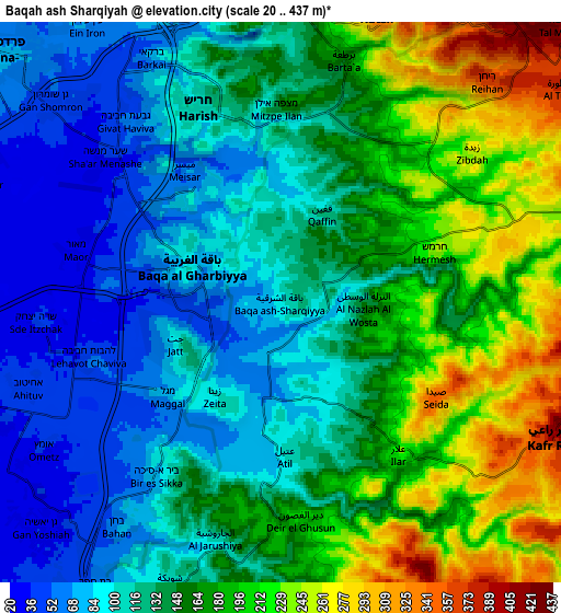
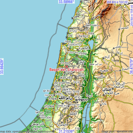
These maps also provides idea of topography and contour of this city, they are displayed at different zoom levels. More info about maps, scale and edge coordinates you can find below images.
| \ | Map #1 | Map #2 | Topo.Map |
| Scale [m] | 34..315 m | 20..437 m | × |
| Scale [ft] | 112..1033 ft | 66..1434 ft | × |
| Average | 108.3 m = 355 ft | 145.3 m = 477 ft | × |
| Width | 8.25 km = 5.1 mi | 16.5 km = 10.3 mi | 264 km = 164 mi |
| Height | 8.25 km = 5.1 mi | 16.5 km = 10.3 mi | 264 km = 164 mi |
| ↑Max Latitude | 32.447412° | 32.48449° | 33.58966° |
| Latitude at center | 32.41032° | 32.41032° | 32.41032° |
| ↓Min Latitude | 32.373212° | 32.336089° | 31.21536° |
| ← Min Longitude | 35.026595° | 34.982649° | 33.66429° |
| Longitude center | 35.07054° | 35.07054° | 35.07054° |
| →Max Longitude | 35.114485° | 35.158431° | 36.47679° |
Nearby cities:
Cities around Bāqah ash Sharqīyah sort by population:
• ‘Attīl elevation 111 m
4.6 km,  178°
178°
• Dayr al Ghuşūn 203 m
6.5 km,  174°
174°
• Qaffīn 126 m
2.7 km,  24°
24°
• Kafr Rā‘ī 399 m
8.9 km,  117°
117°
• ‘Illār 226 m
5.6 km,  142°
142°
• Bal‘ā 352 m
9.3 km,  155°
155°
• Barţa‘ah ash Sharqīyah 185 m
7.3 km, 17°
• Zaytā 99 m
3.3 km,  213°
213°
• Şaydā 350 m
5.3 km, 122°
• Nazlat ‘Īsá 75 m
1.2 km,  298°
298°
• Iktābah 162 m
9.5 km,  190°
190°
• An Nazlah ash Sharqīyah 215 m
3.6 km,  89°
89°
Multilingual:
 En español:
Bāqah ash Sharqīyah elevación 104 m.
 En France:
Bāqah ash Sharqīyah élévation 104 m.
 Auf Deutsch:
Bāqah ash Sharqīyah höhe über dem Meeresspiegel ist 104 m.
 На русском:
Bāqah ash Sharqīyah высота над уровнем моря 104 м
Sources and notes:
- [note 1] Map square and city borders are not equal. Map elevation data is calculated only from area inside that square.
- [src 1] Elevation data from geonames database provided with same terms of usage.
- [src 2] The elevation map of Bāqah ash Sharqīyah is generated using elevation data from NASA's 3 arcsec (90m) resolution SRTM data.
- [src 3] Base (background) map © OpenStreetMap contributors tiles are generated by Geofabrik and OpenTopoMap.
Copyright & License:
This Bāqah ash Sharqīyah Elevation Map is licensed under CC BY-SA. You may reuse any part from this page, if you give a proper credit by linking to this URL:
 More info on terms of use page.