Baytūnyā elevation
Baytūnyā (West Bank, Ramallah), Palestinian Territory elevation is 781 meters and Baytūnyā elevation in feet is 2562 ft above sea level [src 1]. Baytūnyā is a populated place (feature code) with elevation that is 314 meters (1030 ft) bigger than average city elevation in Palestinian Territory.
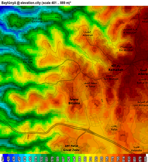
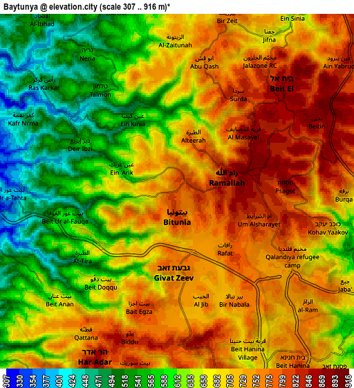
Below is the Elevation map of Baytūnyā, which displays elevation range with different colors. Scale of the first map is from 401 to 889 m (1316 to 2917 ft) with average elevation of 708.7 meters (=2325 ft) [note 1]
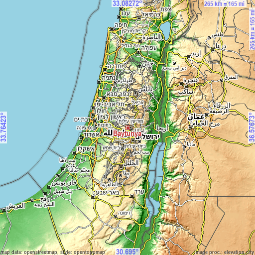
These maps also provides idea of topography and contour of this city, they are displayed at different zoom levels. More info about maps, scale and edge coordinates you can find below images.
| \ | Map #1 | Map #2 | Topo.Map |
| Scale [m] | 401..889 m | 307..916 m | × |
| Scale [ft] | 1316..2917 ft | 1007..3005 ft | × |
| Average | 708.7 m = 2325 ft | 676.5 m = 2219 ft | × |
| Width | 8.3 km = 5.2 mi | 16.59 km = 10.3 mi | 265.5 km = 165 mi |
| Height | 8.3 km = 5.2 mi | 16.59 km = 10.3 mi | 265.5 km = 165 mi |
| ↑Max Latitude | 31.933902° | 31.971189° | 33.08272° |
| Latitude at center | 31.8966° | 31.8966° | 31.8966° |
| ↓Min Latitude | 31.859283° | 31.82195° | 30.695° |
| ← Min Longitude | 35.126535° | 35.082589° | 33.76423° |
| Longitude center | 35.17048° | 35.17048° | 35.17048° |
| →Max Longitude | 35.214425° | 35.258371° | 36.57673° |
Nearby cities:
Cities around Baytūnyā sort by population:
• Al Bīrah elevation 852 m
4.6 km,  71°
71°
• Kalandia 751 m
5.5 km,  127°
127°
• Ramallah 879 m
3.2 km,  83°
83°
• Givat Zeev 754 m
3.9 km,  182°
182°
• Al Jīb 749 m
5.1 km,  165°
165°
• Rāfāt 774 m
3.5 km,  144°
144°
• Al Judayrah 731 m
5.2 km,  151°
151°
• Dayr Ibzī‘ 544 m
5.2 km,  296°
296°
• ‘Ayn ‘Arīk 541 m
2.8 km,  291°
291°
• Aţ Ţīrah 635 m
5.1 km,  234°
234°
• Qalandiyā 765 m
5.2 km, 136°
• Surdā 838 m
5.5 km,  34°
34°
Multilingual:
 En español:
Baytūnyā elevación 781 m.
 En France:
Baytūnyā élévation 781 m.
 Auf Deutsch:
Baytūnyā höhe über dem Meeresspiegel ist 781 m.

Sources and notes:
- [note 1] Map square and city borders are not equal. Map elevation data is calculated only from area inside that square.
- [src 1] Elevation data from geonames database provided with same terms of usage.
- [src 2] The elevation map of Baytūnyā is generated using elevation data from NASA's 3 arcsec (90m) resolution SRTM data.
- [src 3] Base (background) map © OpenStreetMap contributors tiles are generated by Geofabrik and OpenTopoMap.
Copyright & License:
This Baytūnyā Elevation Map is licensed under CC BY-SA. You may reuse any part from this page, if you give a proper credit by linking to this URL:
 More info on terms of use page.