Maythalūn elevation
Maythalūn (West Bank, Jenin), Palestinian Territory elevation is 381 meters and Maythalūn elevation in feet is 1250 ft above sea level [src 1]. Maythalūn is a populated place (feature code) with elevation that is 86 meters (282 ft) smaller than average city elevation in Palestinian Territory.
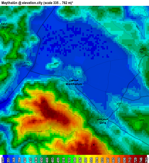
Below is the Elevation map of Maythalūn, which displays elevation range with different colors. Scale of the first map is from 335 to 762 m (1099 to 2500 ft) with average elevation of 446.1 meters (=1464 ft) [note 1]
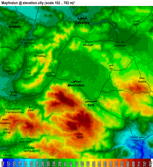
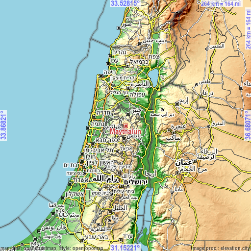
These maps also provides idea of topography and contour of this city, they are displayed at different zoom levels. More info about maps, scale and edge coordinates you can find below images.
| \ | Map #1 | Map #2 | Topo.Map |
| Scale [m] | 335..762 m | 102..762 m | × |
| Scale [ft] | 1099..2500 ft | 335..2500 ft | × |
| Average | 446.1 m = 1464 ft | 413.1 m = 1355 ft | × |
| Width | 8.26 km = 5.1 mi | 16.51 km = 10.3 mi | 264.2 km = 164.2 mi |
| Height | 8.26 km = 5.1 mi | 16.51 km = 10.3 mi | 264.2 km = 164.2 mi |
| ↑Max Latitude | 32.385098° | 32.422201° | 33.52815° |
| Latitude at center | 32.34798° | 32.34798° | 32.34798° |
| ↓Min Latitude | 32.310847° | 32.273698° | 31.15221° |
| ← Min Longitude | 35.230515° | 35.186569° | 33.86821° |
| Longitude center | 35.27446° | 35.27446° | 35.27446° |
| →Max Longitude | 35.318405° | 35.362351° | 36.68071° |
Nearby cities:
Cities around Maythalūn sort by population:
• Qabāţīyah elevation 308 m
7 km,  4°
4°
• Jaba‘ 419 m
5.7 km,  241°
241°
• ‘Ajjah 422 m
7.5 km,  280°
280°
• Sīrīs 425 m
2.7 km,  144°
144°
• Al Judayyidah 425 m
2.9 km,  119°
119°
• Şānūr 386 m
2.9 km,  288°
288°
• Az Zabābidah 346 m
6.3 km,  47°
47°
• Al Fandaqūmīyah 455 m
7.3 km,  245°
245°
• Yāşīd 690 m
5.7 km,  177°
177°
• Mislīyah 415 m
4.4 km,  16°
16°
• ‘Anzah 417 m
5.3 km, 283°
• Mirkah 369 m
6.3 km,  327°
327°
Multilingual:
 En español:
Maythalūn elevación 381 m.
 En France:
Maythalūn élévation 381 m.
 Auf Deutsch:
Maythalūn höhe über dem Meeresspiegel ist 381 m.

Sources and notes:
- [note 1] Map square and city borders are not equal. Map elevation data is calculated only from area inside that square.
- [src 1] Elevation data from geonames database provided with same terms of usage.
- [src 2] The elevation map of Maythalūn is generated using elevation data from NASA's 3 arcsec (90m) resolution SRTM data.
- [src 3] Base (background) map © OpenStreetMap contributors tiles are generated by Geofabrik and OpenTopoMap.
Copyright & License:
This Maythalūn Elevation Map is licensed under CC BY-SA. You may reuse any part from this page, if you give a proper credit by linking to this URL:
 More info on terms of use page.